You are here: Home > Network List > GT - Global Telemetered Seismograph Network (USAF/USGS) Stations List
> Station LPAZ La Paz , Bolivia > Earthquake Result Viewer
LPAZ La Paz , Bolivia - Earthquake Result Viewer
| Earthquake location: |
East Of South Sandwich Islands |
| Earthquake latitude/longitude: |
-60.1/-18.8 |
| Earthquake time(UTC): |
2008/12/14 (349) 20:36:29 GMT |
| Earthquake Depth: |
10 km |
| Earthquake Magnitude: |
5.5 MW, 5.2 MS, 5.3 MB |
| Earthquake Catalog/Contributor: |
WHDF/NEIC |
|
| Network: |
GT Global Telemetered Seismograph Network (USAF/USGS) |
| Station: |
LPAZ La Paz , Bolivia |
| Lat/Lon: |
16.17 S/68.08 W |
| Elevation: |
4817 m |
|
| Distance: |
56.4 deg |
| Az: |
298.958 deg |
| Baz: |
152.839 deg |
| Ray Param: |
0.064174086 |
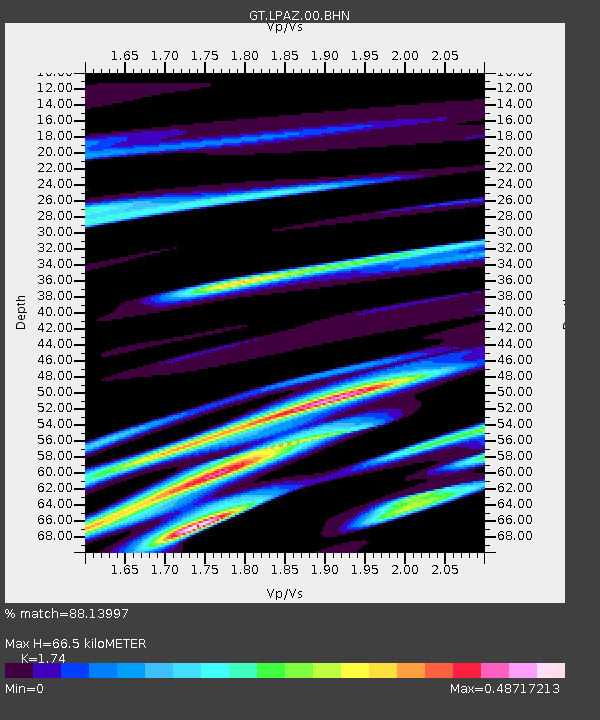
| Estimated Moho Depth: |
66.5 km |
| Estimated Crust Vp/Vs: |
1.74 |
| Assumed Crust Vp: |
6.454 km/s |
| Estimated Crust Vs: |
3.709 km/s |
| Estimated Crust Poisson's Ratio: |
0.25 |
|
| Radial Match: |
88.13997 % |
| Radial Bump: |
400 |
| Transverse Match: |
82.12115 % |
| Transverse Bump: |
400 |
| SOD ConfigId: |
2658 |
| Insert Time: |
2010-02-27 02:10:38.298 +0000 |
| GWidth: |
2.5 |
| Max Bumps: |
400 |
| Tol: |
0.001 |
|
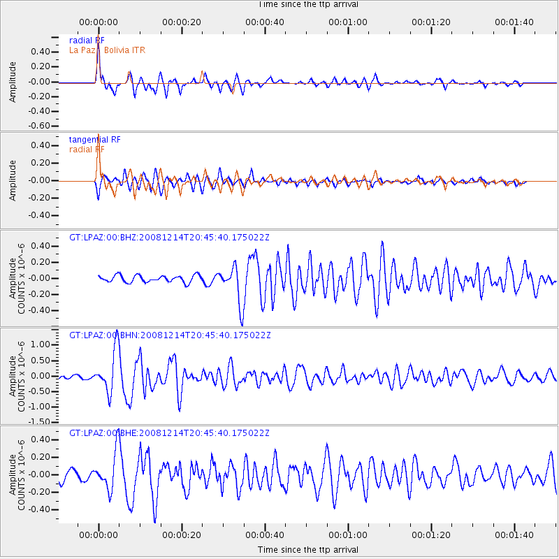
Signal To Noise
| Channel | StoN | STA | LTA |
| GT:LPAZ:00:BHN:20081214T20:45:40.175022Z | 14.624472 | 6.951255E-7 | 4.7531667E-8 |
| GT:LPAZ:00:BHE:20081214T20:45:40.175022Z | 4.7661996 | 2.2163103E-7 | 4.6500578E-8 |
| GT:LPAZ:00:BHZ:20081214T20:45:40.175022Z | 5.7100315 | 2.4142338E-7 | 4.228057E-8 |
| Arrivals |
| Ps | 8.0 SECOND |
| PpPs | 27 SECOND |
| PsPs/PpSs | 35 SECOND |


