You are here: Home > Network List > XD14 - Illuminating the architecture of the greater Mount St. Helens magmatic systems f Stations List
> Station ML10 "Mount St Helens, WA" > Earthquake Result Viewer
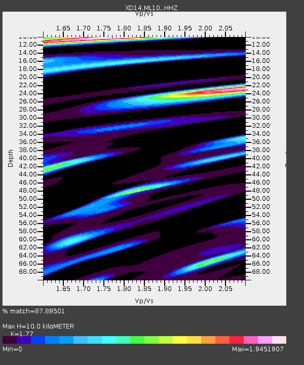
ML10 "Mount St Helens, WA" - Earthquake Result Viewer
| Earthquake location: |
Off East Coast Of Honshu, Japan |
| Earthquake latitude/longitude: |
37.1/142.4 |
| Earthquake time(UTC): |
2014/07/11 (192) 19:22:00 GMT |
| Earthquake Depth: |
13 km |
| Earthquake Magnitude: |
6.8 MWP, 6.8 MI |
| Earthquake Catalog/Contributor: |
NEIC PDE/NEIC COMCAT |
|
| Network: |
XD Illuminating the architecture of the greater Mount St. Helens magmatic systems f |
| Station: |
ML10 "Mount St Helens, WA" |
| Lat/Lon: |
46.05 N/121.75 W |
| Elevation: |
1238 m |
|
| Distance: |
68.1 deg |
| Az: |
48.316 deg |
| Baz: |
300.935 deg |
| Ray Param: |
0.056543533 |
| Estimated Moho Depth: |
10.0 km |
| Estimated Crust Vp/Vs: |
1.77 |
| Assumed Crust Vp: |
6.597 km/s |
| Estimated Crust Vs: |
3.727 km/s |
| Estimated Crust Poisson's Ratio: |
0.27 |
|
| Radial Match: |
87.89501 % |
| Radial Bump: |
400 |
| Transverse Match: |
73.744644 % |
| Transverse Bump: |
400 |
| SOD ConfigId: |
3390531 |
| Insert Time: |
2019-04-12 19:36:36.690 +0000 |
| GWidth: |
2.5 |
| Max Bumps: |
400 |
| Tol: |
0.001 |
|

Signal To Noise
| Channel | StoN | STA | LTA |
| XD:ML10: :HHZ:20140711T19:32:27.679998Z | 4.1479783 | 5.761006E-7 | 1.3888707E-7 |
| XD:ML10: :HHN:20140711T19:32:27.679998Z | 0.6101871 | 1.6627853E-7 | 2.7250417E-7 |
| XD:ML10: :HHE:20140711T19:32:27.679998Z | 1.1580762 | 3.1963702E-7 | 2.760069E-7 |
| Arrivals |
| Ps | 1.2 SECOND |
| PpPs | 4.0 SECOND |
| PsPs/PpSs | 5.2 SECOND |


