You are here: Home > Network List > GT - Global Telemetered Seismograph Network (USAF/USGS) Stations List
> Station LPAZ La Paz , Bolivia > Earthquake Result Viewer
LPAZ La Paz , Bolivia - Earthquake Result Viewer

| Earthquake location: |
Scotia Sea |
| Earthquake latitude/longitude: |
-61.0/-34.4 |
| Earthquake time(UTC): |
2006/08/20 (232) 03:41:47 GMT |
| Earthquake Depth: |
10 km |
| Earthquake Magnitude: |
6.4 MB, 6.8 MS, 7.0 MW, 7.0 MW |
| Earthquake Catalog/Contributor: |
WHDF/NEIC |
|
| Network: |
GT Global Telemetered Seismograph Network (USAF/USGS) |
| Station: |
LPAZ La Paz , Bolivia |
| Lat/Lon: |
16.17 S/68.08 W |
| Elevation: |
4817 m |
|
| Distance: |
50.9 deg |
| Az: |
316.571 deg |
| Baz: |
159.616 deg |
| Ray Param: |
0.06776259 |
| Estimated Moho Depth: |
69.75 km |
| Estimated Crust Vp/Vs: |
1.65 |
| Assumed Crust Vp: |
6.454 km/s |
| Estimated Crust Vs: |
3.911 km/s |
| Estimated Crust Poisson's Ratio: |
0.21 |
|
| Radial Match: |
92.37949 % |
| Radial Bump: |
400 |
| Transverse Match: |
73.24983 % |
| Transverse Bump: |
400 |
| SOD ConfigId: |
2564 |
| Insert Time: |
2010-02-27 02:10:44.280 +0000 |
| GWidth: |
2.5 |
| Max Bumps: |
400 |
| Tol: |
0.001 |
|
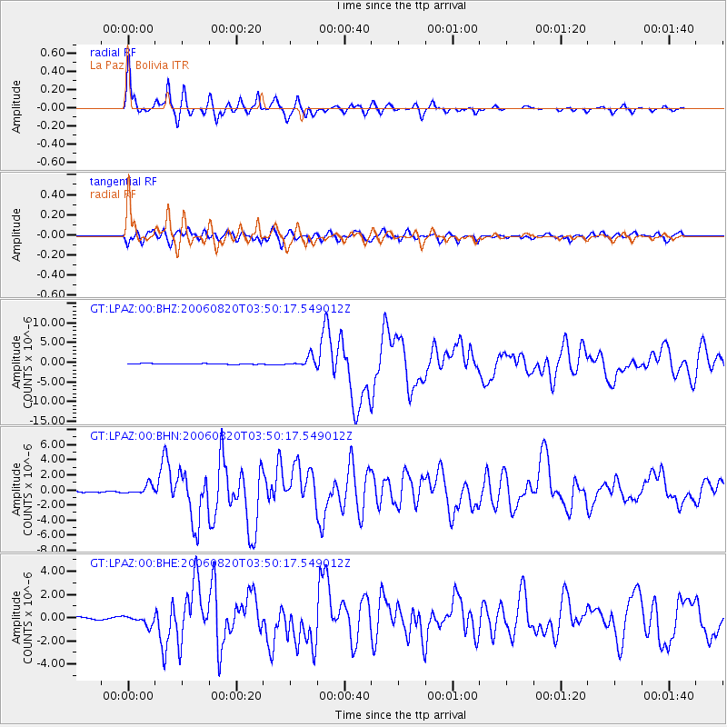
Signal To Noise
| Channel | StoN | STA | LTA |
| GT:LPAZ:00:BHN:20060820T03:50:17.549012Z | 5.5974154 | 6.079401E-7 | 1.0861085E-7 |
| GT:LPAZ:00:BHE:20060820T03:50:17.549012Z | 3.4341094 | 4.383997E-7 | 1.2766039E-7 |
| GT:LPAZ:00:BHZ:20060820T03:50:17.549012Z | 13.000482 | 1.3160623E-6 | 1.0123181E-7 |
| Arrivals |
| Ps | 7.5 SECOND |
| PpPs | 27 SECOND |
| PsPs/PpSs | 34 SECOND |


