You are here: Home > Network List > AZ - ANZA Regional Network Stations List
> Station FRD AZ.FRD > Earthquake Result Viewer
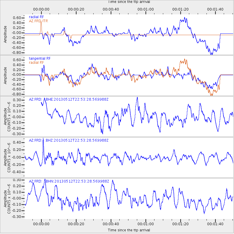
FRD AZ.FRD - Earthquake Result Viewer
*The percent match for this event was below the threshold and hence no stack was calculated.
| Earthquake location: |
Kuril Islands |
| Earthquake latitude/longitude: |
44.0/147.8 |
| Earthquake time(UTC): |
2013/05/12 (132) 22:42:45 GMT |
| Earthquake Depth: |
54 km |
| Earthquake Magnitude: |
5.6 MB, 5.2 MW, 5.1 MW |
| Earthquake Catalog/Contributor: |
WHDF/NEIC |
|
| Network: |
AZ ANZA Regional Network |
| Station: |
FRD AZ.FRD |
| Lat/Lon: |
33.49 N/116.60 W |
| Elevation: |
1164 m |
|
| Distance: |
71.3 deg |
| Az: |
61.423 deg |
| Baz: |
310.631 deg |
| Ray Param: |
$rayparam |
*The percent match for this event was below the threshold and hence was not used in the summary stack. |
|
| Radial Match: |
33.5886 % |
| Radial Bump: |
400 |
| Transverse Match: |
40.803814 % |
| Transverse Bump: |
400 |
| SOD ConfigId: |
508211 |
| Insert Time: |
2013-07-12 10:31:01.059 +0000 |
| GWidth: |
2.5 |
| Max Bumps: |
400 |
| Tol: |
0.001 |
|
Signal To Noise
| Channel | StoN | STA | LTA |
| AZ:FRD: :BHZ:20130512T22:53:28.569988Z | 2.2982295 | 1.733933E-7 | 7.544647E-8 |
| AZ:FRD: :BHN:20130512T22:53:28.569988Z | 1.5698432 | 1.9444356E-7 | 1.2386178E-7 |
| AZ:FRD: :BHE:20130512T22:53:28.569988Z | 1.4829966 | 1.5890588E-7 | 1.07151884E-7 |
| Arrivals |
| Ps | |
| PpPs | |
| PsPs/PpSs | |


