You are here: Home > Network List > CI - Caltech Regional Seismic Network Stations List
> Station MPP McPhearson Peak > Earthquake Result Viewer
MPP McPhearson Peak - Earthquake Result Viewer
*The percent match for this event was below the threshold and hence no stack was calculated.
| Earthquake location: |
Kuril Islands |
| Earthquake latitude/longitude: |
44.0/147.8 |
| Earthquake time(UTC): |
2013/05/12 (132) 22:42:45 GMT |
| Earthquake Depth: |
54 km |
| Earthquake Magnitude: |
5.6 MB, 5.2 MW, 5.1 MW |
| Earthquake Catalog/Contributor: |
WHDF/NEIC |
|
| Network: |
CI Caltech Regional Seismic Network |
| Station: |
MPP McPhearson Peak |
| Lat/Lon: |
34.89 N/119.81 W |
| Elevation: |
1739 m |
|
| Distance: |
68.3 deg |
| Az: |
62.103 deg |
| Baz: |
309.069 deg |
| Ray Param: |
$rayparam |
*The percent match for this event was below the threshold and hence was not used in the summary stack. |
|
| Radial Match: |
50.01323 % |
| Radial Bump: |
400 |
| Transverse Match: |
46.65972 % |
| Transverse Bump: |
400 |
| SOD ConfigId: |
508211 |
| Insert Time: |
2013-07-12 10:33:24.916 +0000 |
| GWidth: |
2.5 |
| Max Bumps: |
400 |
| Tol: |
0.001 |
|
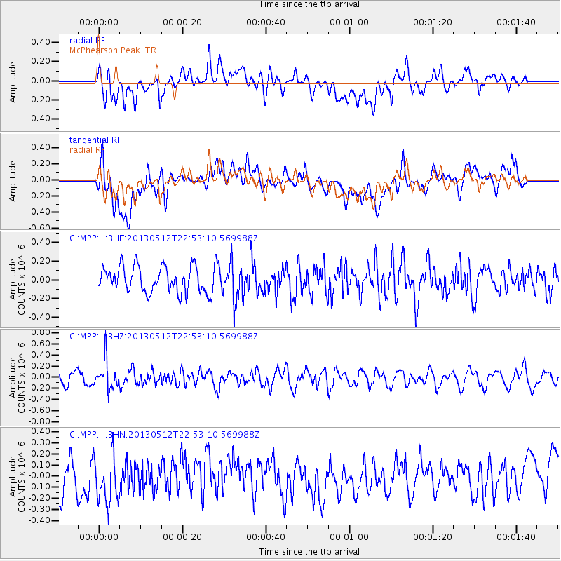
Signal To Noise
| Channel | StoN | STA | LTA |
| CI:MPP: :BHZ:20130512T22:53:10.569988Z | 2.1842399 | 2.536599E-7 | 1.1613189E-7 |
| CI:MPP: :BHN:20130512T22:53:10.569988Z | 1.2193387 | 2.592996E-7 | 2.1265593E-7 |
| CI:MPP: :BHE:20130512T22:53:10.569988Z | 1.4879853 | 1.9738545E-7 | 1.3265281E-7 |
| Arrivals |
| Ps | |
| PpPs | |
| PsPs/PpSs | |


