You are here: Home > Network List > CN - Canadian National Seismograph Network Stations List
> Station INK INUVIK, NT > Earthquake Result Viewer
INK INUVIK, NT - Earthquake Result Viewer
*The percent match for this event was below the threshold and hence no stack was calculated.
| Earthquake location: |
Kuril Islands |
| Earthquake latitude/longitude: |
44.0/147.8 |
| Earthquake time(UTC): |
2013/05/12 (132) 22:42:45 GMT |
| Earthquake Depth: |
54 km |
| Earthquake Magnitude: |
5.6 MB, 5.2 MW, 5.1 MW |
| Earthquake Catalog/Contributor: |
WHDF/NEIC |
|
| Network: |
CN Canadian National Seismograph Network |
| Station: |
INK INUVIK, NT |
| Lat/Lon: |
68.31 N/133.53 W |
| Elevation: |
44 m |
|
| Distance: |
46.0 deg |
| Az: |
30.46 deg |
| Baz: |
280.048 deg |
| Ray Param: |
$rayparam |
*The percent match for this event was below the threshold and hence was not used in the summary stack. |
|
| Radial Match: |
50.63716 % |
| Radial Bump: |
400 |
| Transverse Match: |
57.767403 % |
| Transverse Bump: |
400 |
| SOD ConfigId: |
508211 |
| Insert Time: |
2013-07-12 10:34:12.810 +0000 |
| GWidth: |
2.5 |
| Max Bumps: |
400 |
| Tol: |
0.001 |
|
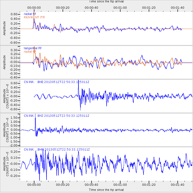
Signal To Noise
| Channel | StoN | STA | LTA |
| CN:INK: :BHZ:20130512T22:50:33.125011Z | 11.417249 | 4.699996E-7 | 4.116575E-8 |
| CN:INK: :BHN:20130512T22:50:33.125011Z | 2.432945 | 1.0207693E-7 | 4.195612E-8 |
| CN:INK: :BHE:20130512T22:50:33.125011Z | 4.090306 | 2.2962588E-7 | 5.6139054E-8 |
| Arrivals |
| Ps | |
| PpPs | |
| PsPs/PpSs | |


