You are here: Home > Network List > IW - Intermountain West Stations List
> Station MOOW Moose Ponds, Wyoming, USA > Earthquake Result Viewer
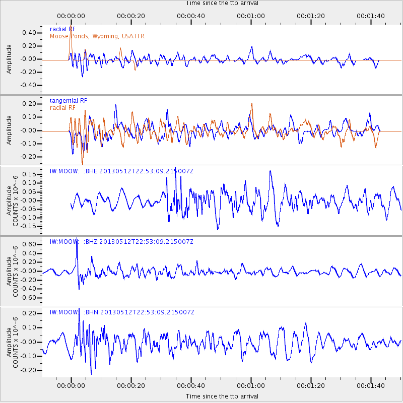
MOOW Moose Ponds, Wyoming, USA - Earthquake Result Viewer
*The percent match for this event was below the threshold and hence no stack was calculated.
| Earthquake location: |
Kuril Islands |
| Earthquake latitude/longitude: |
44.0/147.8 |
| Earthquake time(UTC): |
2013/05/12 (132) 22:42:45 GMT |
| Earthquake Depth: |
54 km |
| Earthquake Magnitude: |
5.6 MB, 5.2 MW, 5.1 MW |
| Earthquake Catalog/Contributor: |
WHDF/NEIC |
|
| Network: |
IW Intermountain West |
| Station: |
MOOW Moose Ponds, Wyoming, USA |
| Lat/Lon: |
43.75 N/110.74 W |
| Elevation: |
2128 m |
|
| Distance: |
68.1 deg |
| Az: |
49.946 deg |
| Baz: |
310.292 deg |
| Ray Param: |
$rayparam |
*The percent match for this event was below the threshold and hence was not used in the summary stack. |
|
| Radial Match: |
64.295715 % |
| Radial Bump: |
400 |
| Transverse Match: |
57.75084 % |
| Transverse Bump: |
400 |
| SOD ConfigId: |
508211 |
| Insert Time: |
2013-07-12 10:35:58.562 +0000 |
| GWidth: |
2.5 |
| Max Bumps: |
400 |
| Tol: |
0.001 |
|
Signal To Noise
| Channel | StoN | STA | LTA |
| IW:MOOW: :BHZ:20130512T22:53:09.215007Z | 4.7286015 | 2.2366649E-7 | 4.730077E-8 |
| IW:MOOW: :BHN:20130512T22:53:09.215007Z | 2.167527 | 8.728481E-8 | 4.0269306E-8 |
| IW:MOOW: :BHE:20130512T22:53:09.215007Z | 1.9508909 | 6.4627216E-8 | 3.3127026E-8 |
| Arrivals |
| Ps | |
| PpPs | |
| PsPs/PpSs | |


