You are here: Home > Network List > GT - Global Telemetered Seismograph Network (USAF/USGS) Stations List
> Station LPAZ La Paz , Bolivia > Earthquake Result Viewer
LPAZ La Paz , Bolivia - Earthquake Result Viewer
| Earthquake location: |
South Sandwich Islands Region |
| Earthquake latitude/longitude: |
-55.9/-29.0 |
| Earthquake time(UTC): |
2002/02/10 (041) 01:47:06 GMT |
| Earthquake Depth: |
193 km |
| Earthquake Magnitude: |
5.7 MB, 6.0 MW, 5.9 MW |
| Earthquake Catalog/Contributor: |
WHDF/NEIC |
|
| Network: |
GT Global Telemetered Seismograph Network (USAF/USGS) |
| Station: |
LPAZ La Paz , Bolivia |
| Lat/Lon: |
16.29 S/68.13 W |
| Elevation: |
4769 m |
|
| Distance: |
49.5 deg |
| Az: |
307.125 deg |
| Baz: |
152.131 deg |
| Ray Param: |
0.06797578 |
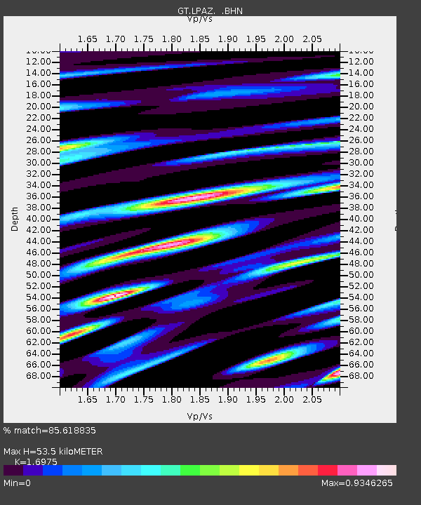
| Estimated Moho Depth: |
53.5 km |
| Estimated Crust Vp/Vs: |
1.70 |
| Assumed Crust Vp: |
6.454 km/s |
| Estimated Crust Vs: |
3.802 km/s |
| Estimated Crust Poisson's Ratio: |
0.23 |
|
| Radial Match: |
85.618835 % |
| Radial Bump: |
400 |
| Transverse Match: |
81.611015 % |
| Transverse Bump: |
400 |
| SOD ConfigId: |
4714 |
| Insert Time: |
2010-02-27 02:11:08.928 +0000 |
| GWidth: |
2.5 |
| Max Bumps: |
400 |
| Tol: |
0.001 |
|
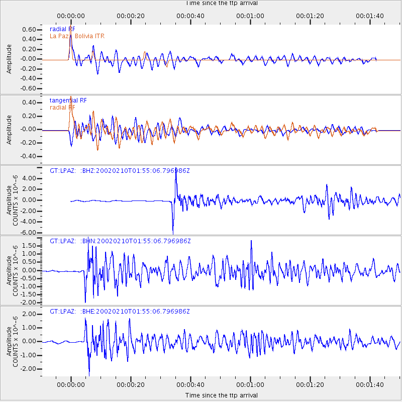
Signal To Noise
| Channel | StoN | STA | LTA |
| GT:LPAZ: :BHN:20020210T01:55:06.796986Z | 4.663279 | 3.432661E-7 | 7.361045E-8 |
| GT:LPAZ: :BHE:20020210T01:55:06.796986Z | 4.1430135 | 3.1392338E-7 | 7.5771744E-8 |
| GT:LPAZ: :BHZ:20020210T01:55:06.796986Z | 16.908049 | 1.1552216E-6 | 6.832377E-8 |
| Arrivals |
| Ps | 6.1 SECOND |
| PpPs | 21 SECOND |
| PsPs/PpSs | 27 SECOND |


