You are here: Home > Network List > GT - Global Telemetered Seismograph Network (USAF/USGS) Stations List
> Station LPAZ La Paz , Bolivia > Earthquake Result Viewer
LPAZ La Paz , Bolivia - Earthquake Result Viewer
| Earthquake location: |
Bouvet Island Region |
| Earthquake latitude/longitude: |
-54.6/1.4 |
| Earthquake time(UTC): |
2003/04/17 (107) 14:50:48 GMT |
| Earthquake Depth: |
10 km |
| Earthquake Magnitude: |
5.5 MB, 6.0 MS, 6.5 MW, 6.5 MW |
| Earthquake Catalog/Contributor: |
WHDF/NEIC |
|
| Network: |
GT Global Telemetered Seismograph Network (USAF/USGS) |
| Station: |
LPAZ La Paz , Bolivia |
| Lat/Lon: |
16.17 S/68.08 W |
| Elevation: |
4817 m |
|
| Distance: |
65.1 deg |
| Az: |
277.134 deg |
| Baz: |
143.095 deg |
| Ray Param: |
0.05848393 |
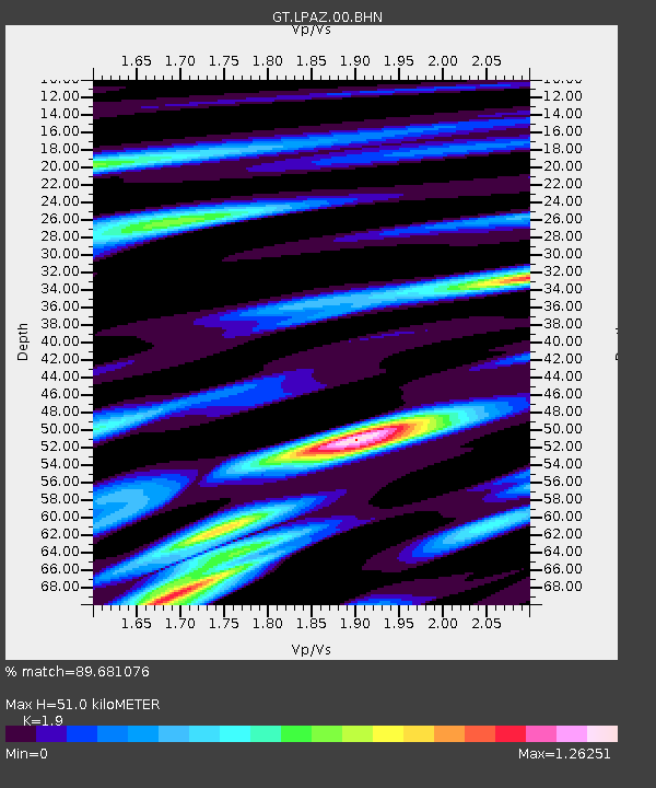
| Estimated Moho Depth: |
51.0 km |
| Estimated Crust Vp/Vs: |
1.90 |
| Assumed Crust Vp: |
6.454 km/s |
| Estimated Crust Vs: |
3.397 km/s |
| Estimated Crust Poisson's Ratio: |
0.31 |
|
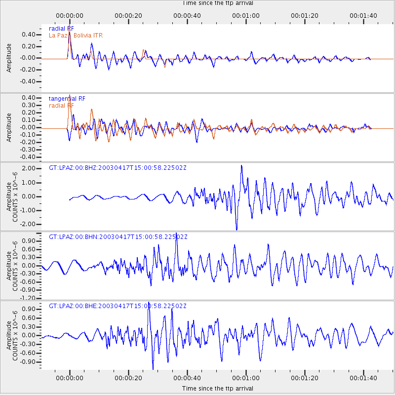
| Radial Match: |
89.681076 % |
| Radial Bump: |
400 |
| Transverse Match: |
77.15616 % |
| Transverse Bump: |
400 |
| SOD ConfigId: |
4714 |
| Insert Time: |
2010-02-27 02:11:13.231 +0000 |
| GWidth: |
2.5 |
| Max Bumps: |
400 |
| Tol: |
0.001 |
|
Signal To Noise
| Channel | StoN | STA | LTA |
| GT:LPAZ:00:BHN:20030417T15:00:58.22502Z | 1.8127613 | 1.476992E-7 | 8.147746E-8 |
| GT:LPAZ:00:BHE:20030417T15:00:58.22502Z | 0.9815234 | 7.122495E-8 | 7.256572E-8 |
| GT:LPAZ:00:BHZ:20030417T15:00:58.22502Z | 2.2266054 | 2.1952674E-7 | 9.859256E-8 |
| Arrivals |
| Ps | 7.4 SECOND |
| PpPs | 22 SECOND |
| PsPs/PpSs | 29 SECOND |


