You are here: Home > Network List > TA - USArray Transportable Network (new EarthScope stations) Stations List
> Station 154A Montrose, GA, USA > Earthquake Result Viewer
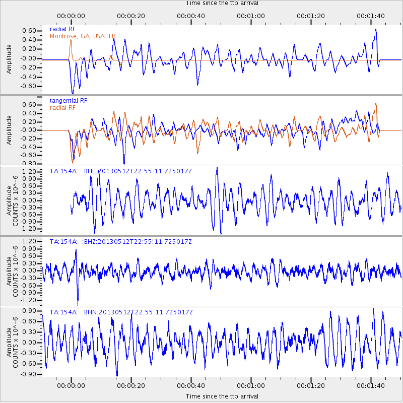
154A Montrose, GA, USA - Earthquake Result Viewer
*The percent match for this event was below the threshold and hence no stack was calculated.
| Earthquake location: |
Kuril Islands |
| Earthquake latitude/longitude: |
44.0/147.8 |
| Earthquake time(UTC): |
2013/05/12 (132) 22:42:45 GMT |
| Earthquake Depth: |
54 km |
| Earthquake Magnitude: |
5.6 MB, 5.2 MW, 5.1 MW |
| Earthquake Catalog/Contributor: |
WHDF/NEIC |
|
| Network: |
TA USArray Transportable Network (new EarthScope stations) |
| Station: |
154A Montrose, GA, USA |
| Lat/Lon: |
32.61 N/83.11 W |
| Elevation: |
111 m |
|
| Distance: |
90.8 deg |
| Az: |
40.929 deg |
| Baz: |
325.905 deg |
| Ray Param: |
$rayparam |
*The percent match for this event was below the threshold and hence was not used in the summary stack. |
|
| Radial Match: |
52.147682 % |
| Radial Bump: |
400 |
| Transverse Match: |
60.738914 % |
| Transverse Bump: |
400 |
| SOD ConfigId: |
508211 |
| Insert Time: |
2013-07-12 10:48:20.475 +0000 |
| GWidth: |
2.5 |
| Max Bumps: |
400 |
| Tol: |
0.001 |
|
Signal To Noise
| Channel | StoN | STA | LTA |
| TA:154A: :BHZ:20130512T22:55:11.725017Z | 2.6226387 | 4.4965793E-7 | 1.7145247E-7 |
| TA:154A: :BHN:20130512T22:55:11.725017Z | 0.7045641 | 3.051112E-7 | 4.330496E-7 |
| TA:154A: :BHE:20130512T22:55:11.725017Z | 0.78750485 | 4.1794252E-7 | 5.307174E-7 |
| Arrivals |
| Ps | |
| PpPs | |
| PsPs/PpSs | |


