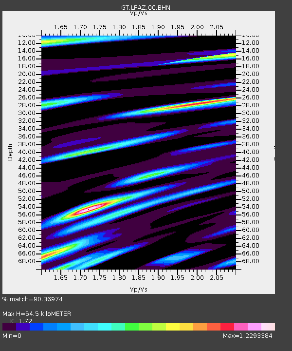
LPAZ La Paz , Bolivia - Earthquake Result Viewer

Earthquake location: South Sandwich Islands Region
Earthquake latitude/longitude: -60.2/-26.9
Earthquake time(UTC): 2009/04/16 (106) 14:57:06 GMT
Earthquake Depth: 20 km
Earthquake Magnitude: 6.2 MB, 6.8 MS, 6.7 MW, 6.7 MW
Earthquake Catalog/Contributor: WHDF/NEIC
Network: GT Global Telemetered Seismograph Network (USAF/USGS)
Station: LPAZ La Paz , Bolivia
Lat/Lon: 16.17 S/68.08 W
Elevation: 4817 m
Distance: 53.1 deg
Az: 307.617 deg
Baz: 155.688 deg
Ray Param: 0.06632003
Estimated Moho Depth: 54.5 km
Estimated Crust Vp/Vs: 1.72
Assumed Crust Vp: 6.454 km/s
Estimated Crust Vs: 3.752 km/s
Estimated Crust Poisson's Ratio: 0.24
Radial Match: 90.36974 %
Radial Bump: 400
Transverse Match: 74.850296 %
Transverse Bump: 400
SOD ConfigId: 2658
Insert Time: 2010-02-27 02:11:33.493 +0000
GWidth: 2.5
Max Bumps: 400
Tol: 0.001

Signal To Noise

ChannelStoNSTALTA
GT:LPAZ:00:BHN:20090416T15:05:51.075Z89.288765.985522E-66.7035565E-8
GT:LPAZ:00:BHE:20090416T15:05:51.075Z35.9807132.3149062E-66.433742E-8
GT:LPAZ:00:BHZ:20090416T15:05:51.075Z31.7832641.664674E-65.23758E-8
Arrivals
Ps6.4 SECOND
PpPs22 SECOND
PsPs/PpSs28 SECOND