You are here: Home > Network List > GS - US Geological Survey Networks Stations List
> Station DEC12 Boyd Road Surface Site > Earthquake Result Viewer
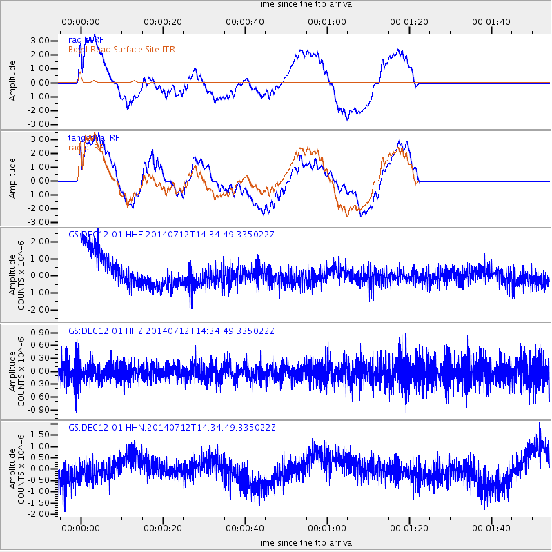
DEC12 Boyd Road Surface Site - Earthquake Result Viewer
*The percent match for this event was below the threshold and hence no stack was calculated.
| Earthquake location: |
Near Coast Of Peru |
| Earthquake latitude/longitude: |
-15.2/-75.6 |
| Earthquake time(UTC): |
2014/07/12 (193) 14:25:41 GMT |
| Earthquake Depth: |
16 km |
| Earthquake Magnitude: |
5.0 MW, 4.9 mb, 5.4 ML |
| Earthquake Catalog/Contributor: |
ISC/ISC |
|
| Network: |
GS US Geological Survey Networks |
| Station: |
DEC12 Boyd Road Surface Site |
| Lat/Lon: |
39.91 N/88.91 W |
| Elevation: |
208 m |
|
| Distance: |
56.2 deg |
| Az: |
347.701 deg |
| Baz: |
164.492 deg |
| Ray Param: |
$rayparam |
*The percent match for this event was below the threshold and hence was not used in the summary stack. |
|
| Radial Match: |
57.787567 % |
| Radial Bump: |
400 |
| Transverse Match: |
47.932583 % |
| Transverse Bump: |
400 |
| SOD ConfigId: |
3390531 |
| Insert Time: |
2019-04-12 19:41:53.886 +0000 |
| GWidth: |
2.5 |
| Max Bumps: |
400 |
| Tol: |
0.001 |
|
Signal To Noise
| Channel | StoN | STA | LTA |
| GS:DEC12:01:HHZ:20140712T14:34:49.335022Z | 1.1260502 | 2.4956316E-7 | 2.2162703E-7 |
| GS:DEC12:01:HHN:20140712T14:34:49.335022Z | 0.45591402 | 4.6717327E-7 | 1.024696E-6 |
| GS:DEC12:01:HHE:20140712T14:34:49.335022Z | 0.64750344 | 6.0939857E-7 | 9.411511E-7 |
| Arrivals |
| Ps | |
| PpPs | |
| PsPs/PpSs | |


