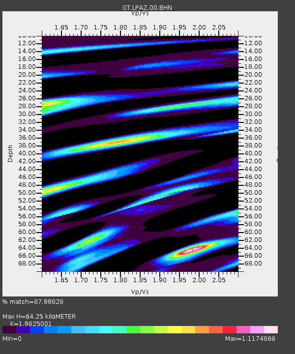
LPAZ La Paz , Bolivia - Earthquake Result Viewer
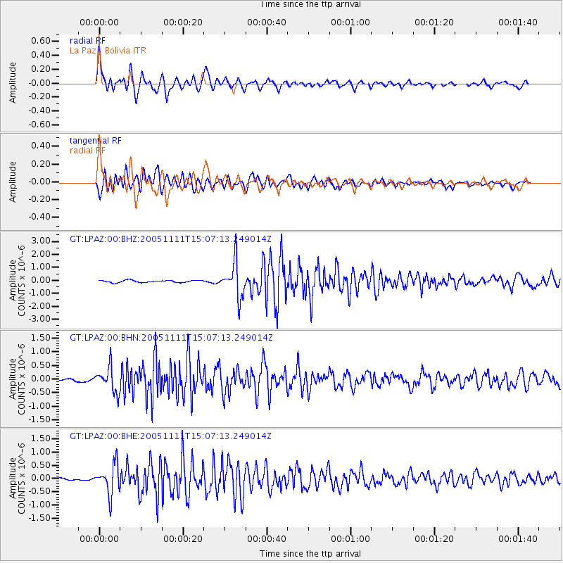
Earthquake location: South Sandwich Islands Region
Earthquake latitude/longitude: -55.7/-27.1
Earthquake time(UTC): 2005/11/11 (315) 14:58:50 GMT
Earthquake Depth: 29 km
Earthquake Magnitude: 5.7 MB, 5.4 MS, 5.9 MW, 5.8 MW
Earthquake Catalog/Contributor: WHDF/NEIC
Network: GT Global Telemetered Seismograph Network (USAF/USGS)
Station: LPAZ La Paz , Bolivia
Lat/Lon: 16.17 S/68.08 W
Elevation: 4817 m
Distance: 50.3 deg
Az: 304.963 deg
Baz: 151.129 deg
Ray Param: 0.068092175
Estimated Moho Depth: 64.25 km
Estimated Crust Vp/Vs: 1.98
Assumed Crust Vp: 6.454 km/s
Estimated Crust Vs: 3.255 km/s
Estimated Crust Poisson's Ratio: 0.33
Radial Match: 87.99828 %
Radial Bump: 400
Transverse Match: 85.61573 %
Transverse Bump: 400
SOD ConfigId: 2422
Insert Time: 2010-02-27 02:11:39.084 +0000
GWidth: 2.5
Max Bumps: 400
Tol: 0.001

Signal To Noise

ChannelStoNSTALTA
GT:LPAZ:00:BHN:20051111T15:07:13.249014Z8.1114744.6557514E-75.7397102E-8
GT:LPAZ:00:BHE:20051111T15:07:13.249014Z10.0970295.81794E-75.7620312E-8
GT:LPAZ:00:BHZ:20051111T15:07:13.249014Z16.6026461.3952747E-68.403929E-8
Arrivals
Ps10 SECOND
PpPs28 SECOND
PsPs/PpSs38 SECOND