You are here: Home > Network List > TA - USArray Transportable Network (new EarthScope stations) Stations List
> Station G65A Princeton, ME, USA > Earthquake Result Viewer
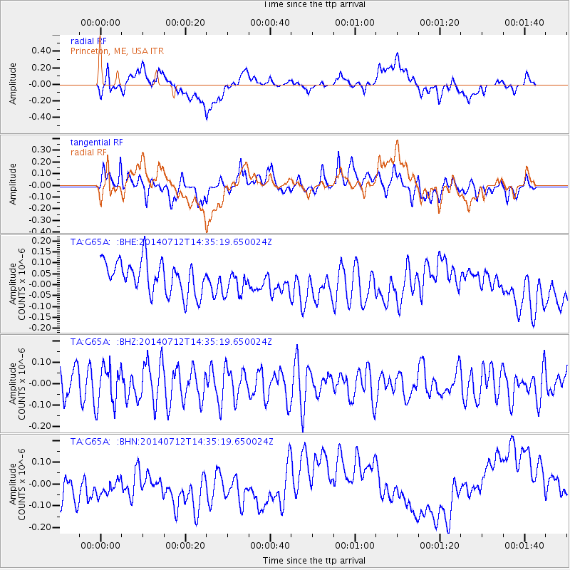
G65A Princeton, ME, USA - Earthquake Result Viewer
*The percent match for this event was below the threshold and hence no stack was calculated.
| Earthquake location: |
Near Coast Of Peru |
| Earthquake latitude/longitude: |
-15.2/-75.6 |
| Earthquake time(UTC): |
2014/07/12 (193) 14:25:41 GMT |
| Earthquake Depth: |
16 km |
| Earthquake Magnitude: |
5.0 MW, 4.9 mb, 5.4 ML |
| Earthquake Catalog/Contributor: |
ISC/ISC |
|
| Network: |
TA USArray Transportable Network (new EarthScope stations) |
| Station: |
G65A Princeton, ME, USA |
| Lat/Lon: |
45.20 N/67.56 W |
| Elevation: |
78 m |
|
| Distance: |
60.5 deg |
| Az: |
6.521 deg |
| Baz: |
188.922 deg |
| Ray Param: |
$rayparam |
*The percent match for this event was below the threshold and hence was not used in the summary stack. |
|
| Radial Match: |
17.89483 % |
| Radial Bump: |
400 |
| Transverse Match: |
46.717712 % |
| Transverse Bump: |
400 |
| SOD ConfigId: |
3390531 |
| Insert Time: |
2019-04-12 19:44:29.519 +0000 |
| GWidth: |
2.5 |
| Max Bumps: |
400 |
| Tol: |
0.001 |
|
Signal To Noise
| Channel | StoN | STA | LTA |
| TA:G65A: :BHZ:20140712T14:35:19.650024Z | 1.415984 | 8.845251E-8 | 6.2467166E-8 |
| TA:G65A: :BHN:20140712T14:35:19.650024Z | 1.1853096 | 1.0026463E-7 | 8.45894E-8 |
| TA:G65A: :BHE:20140712T14:35:19.650024Z | 0.7953143 | 5.8397987E-8 | 7.342756E-8 |
| Arrivals |
| Ps | |
| PpPs | |
| PsPs/PpSs | |


