You are here: Home > Network List > TA - USArray Transportable Network (new EarthScope stations) Stations List
> Station G03D McMinnville, OR, USA > Earthquake Result Viewer
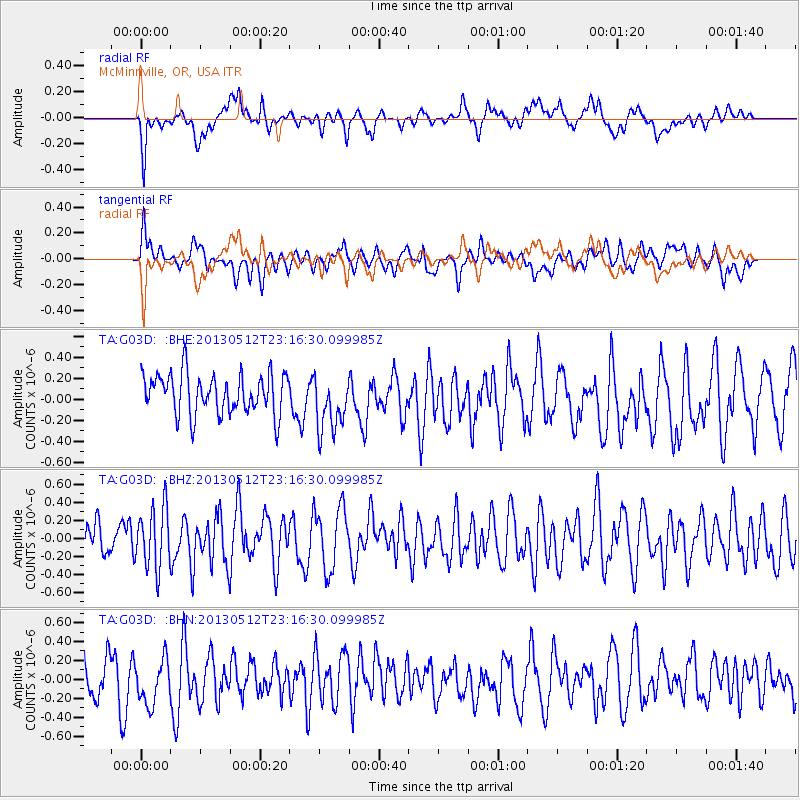
G03D McMinnville, OR, USA - Earthquake Result Viewer
*The percent match for this event was below the threshold and hence no stack was calculated.
| Earthquake location: |
Mariana Islands Region |
| Earthquake latitude/longitude: |
21.9/143.7 |
| Earthquake time(UTC): |
2013/05/12 (132) 23:05:27 GMT |
| Earthquake Depth: |
167 km |
| Earthquake Magnitude: |
5.5 MW, 5.1 MB, 5.6 MW |
| Earthquake Catalog/Contributor: |
WHDF/NEIC |
|
| Network: |
TA USArray Transportable Network (new EarthScope stations) |
| Station: |
G03D McMinnville, OR, USA |
| Lat/Lon: |
45.21 N/123.26 W |
| Elevation: |
222 m |
|
| Distance: |
76.8 deg |
| Az: |
46.477 deg |
| Baz: |
287.755 deg |
| Ray Param: |
$rayparam |
*The percent match for this event was below the threshold and hence was not used in the summary stack. |
|
| Radial Match: |
65.49162 % |
| Radial Bump: |
400 |
| Transverse Match: |
44.54351 % |
| Transverse Bump: |
400 |
| SOD ConfigId: |
508211 |
| Insert Time: |
2013-07-12 11:06:04.571 +0000 |
| GWidth: |
2.5 |
| Max Bumps: |
400 |
| Tol: |
0.001 |
|
Signal To Noise
| Channel | StoN | STA | LTA |
| TA:G03D: :BHZ:20130512T23:16:30.099985Z | 1.6767588 | 3.328044E-7 | 1.9848079E-7 |
| TA:G03D: :BHN:20130512T23:16:30.099985Z | 0.8261197 | 2.4752373E-7 | 2.996221E-7 |
| TA:G03D: :BHE:20130512T23:16:30.099985Z | 1.4005656 | 2.702258E-7 | 1.9294048E-7 |
| Arrivals |
| Ps | |
| PpPs | |
| PsPs/PpSs | |


