You are here: Home > Network List > TA - USArray Transportable Network (new EarthScope stations) Stations List
> Station E42A Champion, MI, USA > Earthquake Result Viewer
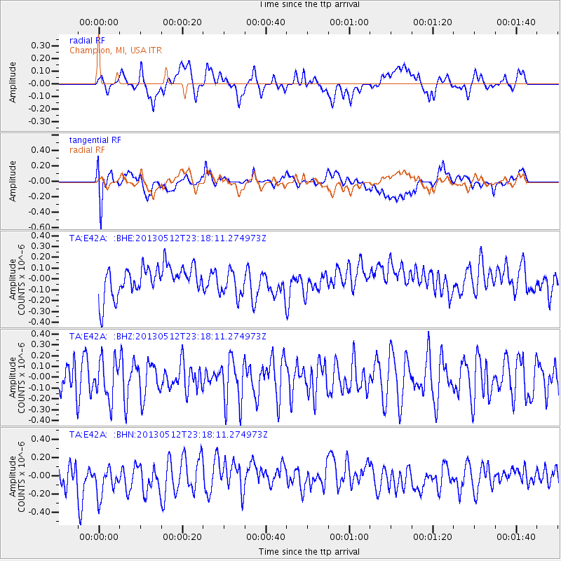
E42A Champion, MI, USA - Earthquake Result Viewer
*The percent match for this event was below the threshold and hence no stack was calculated.
| Earthquake location: |
Mariana Islands Region |
| Earthquake latitude/longitude: |
21.9/143.7 |
| Earthquake time(UTC): |
2013/05/12 (132) 23:05:27 GMT |
| Earthquake Depth: |
167 km |
| Earthquake Magnitude: |
5.5 MW, 5.1 MB, 5.6 MW |
| Earthquake Catalog/Contributor: |
WHDF/NEIC |
|
| Network: |
TA USArray Transportable Network (new EarthScope stations) |
| Station: |
E42A Champion, MI, USA |
| Lat/Lon: |
46.43 N/87.91 W |
| Elevation: |
475 m |
|
| Distance: |
97.5 deg |
| Az: |
33.171 deg |
| Baz: |
312.741 deg |
| Ray Param: |
$rayparam |
*The percent match for this event was below the threshold and hence was not used in the summary stack. |
|
| Radial Match: |
42.841473 % |
| Radial Bump: |
400 |
| Transverse Match: |
53.962387 % |
| Transverse Bump: |
400 |
| SOD ConfigId: |
508211 |
| Insert Time: |
2013-07-12 11:07:02.447 +0000 |
| GWidth: |
2.5 |
| Max Bumps: |
400 |
| Tol: |
0.001 |
|
Signal To Noise
| Channel | StoN | STA | LTA |
| TA:E42A: :BHZ:20130512T23:18:11.274973Z | 1.1544533 | 1.8309332E-7 | 1.5859742E-7 |
| TA:E42A: :BHN:20130512T23:18:11.274973Z | 1.6731083 | 1.9469357E-7 | 1.16366394E-7 |
| TA:E42A: :BHE:20130512T23:18:11.274973Z | 0.96498233 | 1.2883011E-7 | 1.3350514E-7 |
| Arrivals |
| Ps | |
| PpPs | |
| PsPs/PpSs | |


