You are here: Home > Network List > GT - Global Telemetered Seismograph Network (USAF/USGS) Stations List
> Station LPAZ La Paz , Bolivia > Earthquake Result Viewer
LPAZ La Paz , Bolivia - Earthquake Result Viewer
| Earthquake location: |
West Chile Rise |
| Earthquake latitude/longitude: |
-36.3/-97.3 |
| Earthquake time(UTC): |
2005/07/10 (191) 04:46:31 GMT |
| Earthquake Depth: |
10 km |
| Earthquake Magnitude: |
5.3 MB, 5.7 MS, 6.1 MW, 6.0 MW |
| Earthquake Catalog/Contributor: |
WHDF/NEIC |
|
| Network: |
GT Global Telemetered Seismograph Network (USAF/USGS) |
| Station: |
LPAZ La Paz , Bolivia |
| Lat/Lon: |
16.17 S/68.08 W |
| Elevation: |
4817 m |
|
| Distance: |
32.8 deg |
| Az: |
59.956 deg |
| Baz: |
226.687 deg |
| Ray Param: |
0.07850911 |
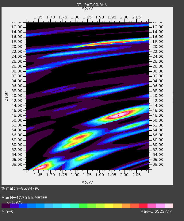
| Estimated Moho Depth: |
47.75 km |
| Estimated Crust Vp/Vs: |
1.98 |
| Assumed Crust Vp: |
6.454 km/s |
| Estimated Crust Vs: |
3.268 km/s |
| Estimated Crust Poisson's Ratio: |
0.33 |
|
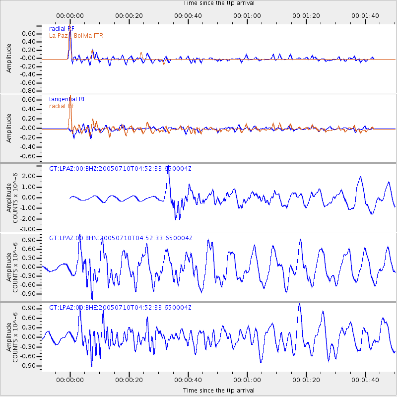
| Radial Match: |
85.84796 % |
| Radial Bump: |
400 |
| Transverse Match: |
65.14398 % |
| Transverse Bump: |
400 |
| SOD ConfigId: |
2475 |
| Insert Time: |
2010-02-27 02:11:49.001 +0000 |
| GWidth: |
2.5 |
| Max Bumps: |
400 |
| Tol: |
0.001 |
|
Signal To Noise
| Channel | StoN | STA | LTA |
| GT:LPAZ:00:BHN:20050710T04:52:33.650004Z | 4.064968 | 4.1015383E-7 | 1.0089965E-7 |
| GT:LPAZ:00:BHE:20050710T04:52:33.650004Z | 3.0904021 | 3.4812962E-7 | 1.1264864E-7 |
| GT:LPAZ:00:BHZ:20050710T04:52:33.650004Z | 6.000351 | 1.108902E-6 | 1.848062E-7 |
| Arrivals |
| Ps | 7.7 SECOND |
| PpPs | 21 SECOND |
| PsPs/PpSs | 28 SECOND |


