You are here: Home > Network List > TA - USArray Transportable Network (new EarthScope stations) Stations List
> Station V60A Jim Taylor Road, Stokes, NC, USA > Earthquake Result Viewer
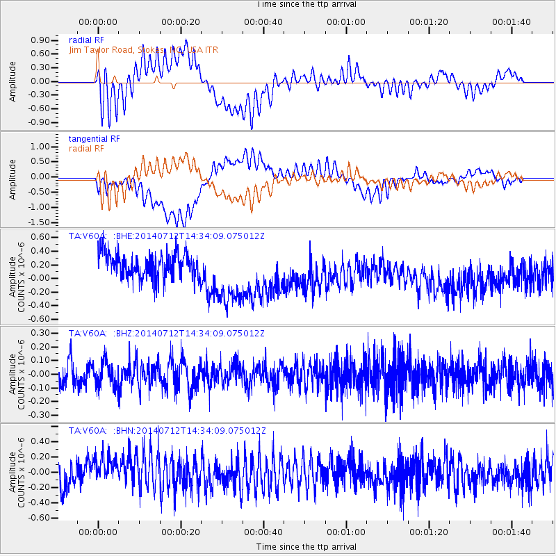
V60A Jim Taylor Road, Stokes, NC, USA - Earthquake Result Viewer
*The percent match for this event was below the threshold and hence no stack was calculated.
| Earthquake location: |
Near Coast Of Peru |
| Earthquake latitude/longitude: |
-15.2/-75.6 |
| Earthquake time(UTC): |
2014/07/12 (193) 14:25:41 GMT |
| Earthquake Depth: |
16 km |
| Earthquake Magnitude: |
5.0 MW, 4.9 mb, 5.4 ML |
| Earthquake Catalog/Contributor: |
ISC/ISC |
|
| Network: |
TA USArray Transportable Network (new EarthScope stations) |
| Station: |
V60A Jim Taylor Road, Stokes, NC, USA |
| Lat/Lon: |
35.76 N/77.26 W |
| Elevation: |
8.0 m |
|
| Distance: |
50.7 deg |
| Az: |
358.256 deg |
| Baz: |
177.929 deg |
| Ray Param: |
$rayparam |
*The percent match for this event was below the threshold and hence was not used in the summary stack. |
|
| Radial Match: |
54.410156 % |
| Radial Bump: |
400 |
| Transverse Match: |
41.42552 % |
| Transverse Bump: |
400 |
| SOD ConfigId: |
3390531 |
| Insert Time: |
2019-04-12 19:45:18.196 +0000 |
| GWidth: |
2.5 |
| Max Bumps: |
400 |
| Tol: |
0.001 |
|
Signal To Noise
| Channel | StoN | STA | LTA |
| TA:V60A: :BHZ:20140712T14:34:09.075012Z | 1.0586398 | 8.867516E-8 | 8.37633E-8 |
| TA:V60A: :BHN:20140712T14:34:09.075012Z | 1.0096589 | 1.9941855E-7 | 1.9751079E-7 |
| TA:V60A: :BHE:20140712T14:34:09.075012Z | 2.6324904 | 4.778693E-7 | 1.8152747E-7 |
| Arrivals |
| Ps | |
| PpPs | |
| PsPs/PpSs | |


