You are here: Home > Network List > G - GEOSCOPE Stations List
> Station CAN Canberra, Australia > Earthquake Result Viewer
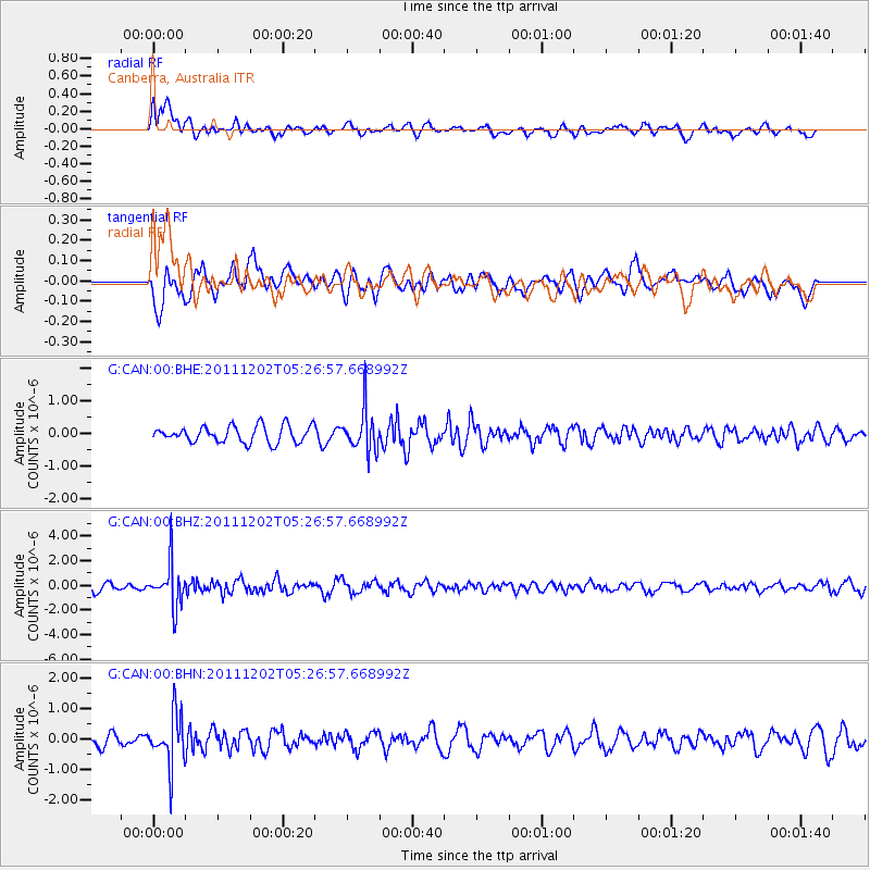
CAN Canberra, Australia - Earthquake Result Viewer
*The percent match for this event was below the threshold and hence no stack was calculated.
| Earthquake location: |
Minahassa Peninsula, Sulawesi |
| Earthquake latitude/longitude: |
0.1/120.5 |
| Earthquake time(UTC): |
2011/12/02 (336) 05:19:26 GMT |
| Earthquake Depth: |
75 km |
| Earthquake Magnitude: |
5.5 MW, 5.5 MW, 5.9 MB |
| Earthquake Catalog/Contributor: |
NEIC PDE/NEIC PDE-W |
|
| Network: |
G GEOSCOPE |
| Station: |
CAN Canberra, Australia |
| Lat/Lon: |
35.32 S/149.00 E |
| Elevation: |
650 m |
|
| Distance: |
44.2 deg |
| Az: |
145.935 deg |
| Baz: |
316.767 deg |
| Ray Param: |
$rayparam |
*The percent match for this event was below the threshold and hence was not used in the summary stack. |
|
| Radial Match: |
52.053257 % |
| Radial Bump: |
400 |
| Transverse Match: |
69.66002 % |
| Transverse Bump: |
400 |
| SOD ConfigId: |
510226 |
| Insert Time: |
2013-09-04 18:50:08.423 +0000 |
| GWidth: |
2.5 |
| Max Bumps: |
400 |
| Tol: |
0.001 |
|
Signal To Noise
| Channel | StoN | STA | LTA |
| G:CAN:00:BHZ:20111202T05:26:57.668992Z | 5.7247195 | 1.7468202E-6 | 3.0513635E-7 |
| G:CAN:00:BHN:20111202T05:26:57.668992Z | 4.238417 | 8.06128E-7 | 1.9019554E-7 |
| G:CAN:00:BHE:20111202T05:26:57.668992Z | 2.580666 | 6.4327014E-7 | 2.4926516E-7 |
| Arrivals |
| Ps | |
| PpPs | |
| PsPs/PpSs | |


