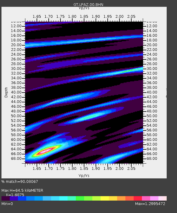
LPAZ La Paz , Bolivia - Earthquake Result Viewer

Earthquake location: Near Coast Of Chiapas, Mexico
Earthquake latitude/longitude: 14.4/-92.4
Earthquake time(UTC): 2008/10/16 (290) 19:41:25 GMT
Earthquake Depth: 24 km
Earthquake Magnitude: 6.1 MB, 6.6 MS, 6.7 MW, 6.6 MW
Earthquake Catalog/Contributor: WHDF/NEIC
Network: GT Global Telemetered Seismograph Network (USAF/USGS)
Station: LPAZ La Paz , Bolivia
Lat/Lon: 16.17 S/68.08 W
Elevation: 4817 m
Distance: 38.7 deg
Az: 140.824 deg
Baz: 320.436 deg
Ray Param: 0.07535695
Estimated Moho Depth: 64.5 km
Estimated Crust Vp/Vs: 1.69
Assumed Crust Vp: 6.454 km/s
Estimated Crust Vs: 3.825 km/s
Estimated Crust Poisson's Ratio: 0.23
Radial Match: 90.08067 %
Radial Bump: 400
Transverse Match: 72.21485 %
Transverse Bump: 400
SOD ConfigId: 2556
Insert Time: 2010-02-27 02:12:00.656 +0000
GWidth: 2.5
Max Bumps: 400
Tol: 0.001

Signal To Noise

ChannelStoNSTALTA
GT:LPAZ:00:BHN:20081016T19:48:17.17401Z9.4955988.104973E-78.5355055E-8
GT:LPAZ:00:BHE:20081016T19:48:17.17401Z3.9953713.3215056E-78.313385E-8
GT:LPAZ:00:BHZ:20081016T19:48:17.17401Z2.99658422.5049872E-78.3594756E-8
Arrivals
Ps7.4 SECOND
PpPs25 SECOND
PsPs/PpSs32 SECOND