You are here: Home > Network List > II - Global Seismograph Network (GSN - IRIS/IDA) Stations List
> Station ABPO Ambohimpanompo, Madagascar > Earthquake Result Viewer
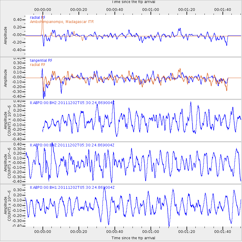
ABPO Ambohimpanompo, Madagascar - Earthquake Result Viewer
*The percent match for this event was below the threshold and hence no stack was calculated.
| Earthquake location: |
Minahassa Peninsula, Sulawesi |
| Earthquake latitude/longitude: |
0.1/120.5 |
| Earthquake time(UTC): |
2011/12/02 (336) 05:19:26 GMT |
| Earthquake Depth: |
75 km |
| Earthquake Magnitude: |
5.5 MW, 5.5 MW, 5.9 MB |
| Earthquake Catalog/Contributor: |
NEIC PDE/NEIC PDE-W |
|
| Network: |
II Global Seismograph Network (GSN - IRIS/IDA) |
| Station: |
ABPO Ambohimpanompo, Madagascar |
| Lat/Lon: |
19.02 S/47.23 E |
| Elevation: |
1528 m |
|
| Distance: |
74.2 deg |
| Az: |
250.296 deg |
| Baz: |
84.321 deg |
| Ray Param: |
$rayparam |
*The percent match for this event was below the threshold and hence was not used in the summary stack. |
|
| Radial Match: |
49.731693 % |
| Radial Bump: |
400 |
| Transverse Match: |
67.49366 % |
| Transverse Bump: |
400 |
| SOD ConfigId: |
510226 |
| Insert Time: |
2013-09-04 18:54:06.153 +0000 |
| GWidth: |
2.5 |
| Max Bumps: |
400 |
| Tol: |
0.001 |
|
Signal To Noise
| Channel | StoN | STA | LTA |
| II:ABPO:00:BHZ:20111202T05:30:24.869004Z | 1.5383512 | 2.1872049E-7 | 1.4217852E-7 |
| II:ABPO:00:BH1:20111202T05:30:24.869004Z | 0.79881305 | 8.805474E-8 | 1.1023197E-7 |
| II:ABPO:00:BH2:20111202T05:30:24.869004Z | 1.635863 | 1.7760564E-7 | 1.08570006E-7 |
| Arrivals |
| Ps | |
| PpPs | |
| PsPs/PpSs | |


