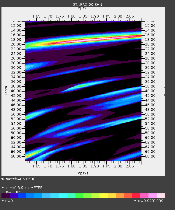
LPAZ La Paz , Bolivia - Earthquake Result Viewer
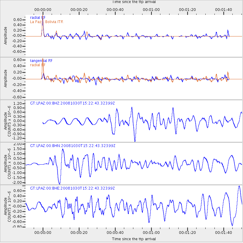
Earthquake location: Central East Pacific Rise
Earthquake latitude/longitude: -9.0/-108.2
Earthquake time(UTC): 2008/10/30 (304) 15:15:41 GMT
Earthquake Depth: 10 km
Earthquake Magnitude: 5.5 MB, 5.8 MS, 6.0 MW, 6.0 MW
Earthquake Catalog/Contributor: WHDF/NEIC
Network: GT Global Telemetered Seismograph Network (USAF/USGS)
Station: LPAZ La Paz , Bolivia
Lat/Lon: 16.17 S/68.08 W
Elevation: 4817 m
Distance: 39.8 deg
Az: 104.393 deg
Baz: 275.315 deg
Ray Param: 0.07478264
Estimated Moho Depth: 18.0 km
Estimated Crust Vp/Vs: 1.87
Assumed Crust Vp: 6.454 km/s
Estimated Crust Vs: 3.461 km/s
Estimated Crust Poisson's Ratio: 0.30
Radial Match: 85.8588 %
Radial Bump: 391
Transverse Match: 69.883865 %
Transverse Bump: 373
SOD ConfigId: 2560
Insert Time: 2010-02-27 02:12:02.118 +0000
GWidth: 2.5
Max Bumps: 400
Tol: 0.001

Signal To Noise

ChannelStoNSTALTA
GT:LPAZ:00:BHN:20081030T15:22:43.32399Z2.9771812.6967544E-79.0580805E-8
GT:LPAZ:00:BHE:20081030T15:22:43.32399Z0.943996979.1837265E-89.728555E-8
GT:LPAZ:00:BHZ:20081030T15:22:43.32399Z0.98373161.4292382E-71.4528743E-7
Arrivals
Ps2.6 SECOND
PpPs7.5 SECOND
PsPs/PpSs10 SECOND