You are here: Home > Network List > GT - Global Telemetered Seismograph Network (USAF/USGS) Stations List
> Station LPAZ La Paz , Bolivia > Earthquake Result Viewer
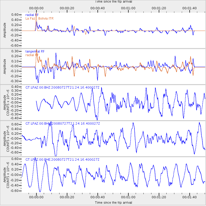
LPAZ La Paz , Bolivia - Earthquake Result Viewer
*The percent match for this event was below the threshold and hence no stack was calculated.
| Earthquake location: |
Central Mid-Atlantic Ridge |
| Earthquake latitude/longitude: |
-0.3/-18.3 |
| Earthquake time(UTC): |
2008/07/27 (209) 21:15:41 GMT |
| Earthquake Depth: |
10 km |
| Earthquake Magnitude: |
5.8 MB, 5.3 MS, 5.9 MW, 5.8 MW |
| Earthquake Catalog/Contributor: |
WHDF/NEIC |
|
| Network: |
GT Global Telemetered Seismograph Network (USAF/USGS) |
| Station: |
LPAZ La Paz , Bolivia |
| Lat/Lon: |
16.17 S/68.08 W |
| Elevation: |
4817 m |
|
| Distance: |
51.6 deg |
| Az: |
249.515 deg |
| Baz: |
77.123 deg |
| Ray Param: |
$rayparam |
*The percent match for this event was below the threshold and hence was not used in the summary stack. |
|
| Radial Match: |
57.883728 % |
| Radial Bump: |
400 |
| Transverse Match: |
58.613964 % |
| Transverse Bump: |
400 |
| SOD ConfigId: |
2504 |
| Insert Time: |
2010-02-27 02:12:07.481 +0000 |
| GWidth: |
2.5 |
| Max Bumps: |
400 |
| Tol: |
0.001 |
|
Signal To Noise
| Channel | StoN | STA | LTA |
| GT:LPAZ:00:BHN:20080727T21:24:16.400027Z | 1.1723847 | 1.2581788E-7 | 1.073179E-7 |
| GT:LPAZ:00:BHE:20080727T21:24:16.400027Z | 2.7654355 | 4.4273258E-7 | 1.6009507E-7 |
| GT:LPAZ:00:BHZ:20080727T21:24:16.400027Z | 1.6805298 | 1.4795023E-7 | 8.8037844E-8 |
| Arrivals |
| Ps | |
| PpPs | |
| PsPs/PpSs | |


