You are here: Home > Network List > II - Global Seismograph Network (GSN - IRIS/IDA) Stations List
> Station WRAB Tennant Creek, NT, Australia > Earthquake Result Viewer
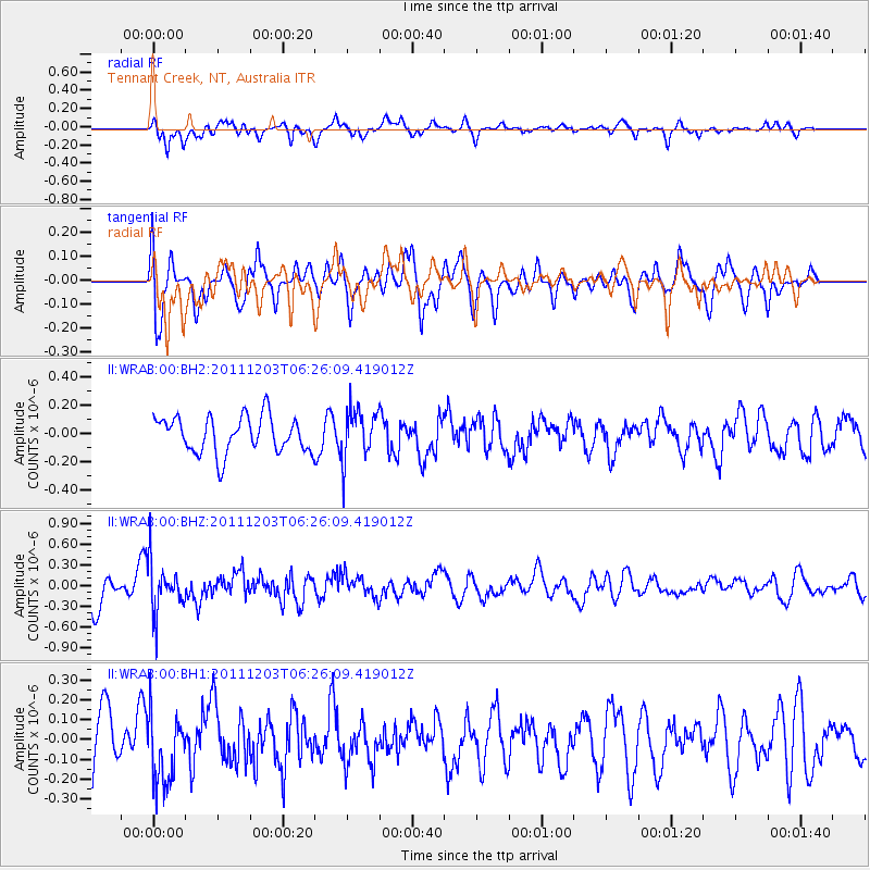
WRAB Tennant Creek, NT, Australia - Earthquake Result Viewer
*The percent match for this event was below the threshold and hence no stack was calculated.
| Earthquake location: |
Cook Strait, New Zealand |
| Earthquake latitude/longitude: |
-41.4/174.3 |
| Earthquake time(UTC): |
2011/12/03 (337) 06:19:10 GMT |
| Earthquake Depth: |
56 km |
| Earthquake Magnitude: |
5.7 ML |
| Earthquake Catalog/Contributor: |
NEIC PDE/NEIC PDE-W |
|
| Network: |
II Global Seismograph Network (GSN - IRIS/IDA) |
| Station: |
WRAB Tennant Creek, NT, Australia |
| Lat/Lon: |
19.93 S/134.36 E |
| Elevation: |
366 m |
|
| Distance: |
40.0 deg |
| Az: |
289.981 deg |
| Baz: |
131.244 deg |
| Ray Param: |
$rayparam |
*The percent match for this event was below the threshold and hence was not used in the summary stack. |
|
| Radial Match: |
70.24521 % |
| Radial Bump: |
400 |
| Transverse Match: |
59.96491 % |
| Transverse Bump: |
400 |
| SOD ConfigId: |
510226 |
| Insert Time: |
2013-09-04 19:05:41.401 +0000 |
| GWidth: |
2.5 |
| Max Bumps: |
400 |
| Tol: |
0.001 |
|
Signal To Noise
| Channel | StoN | STA | LTA |
| II:WRAB:00:BHZ:20111203T06:26:09.419012Z | 1.6600615 | 3.4728217E-7 | 2.0919836E-7 |
| II:WRAB:00:BH1:20111203T06:26:09.419012Z | 1.2105113 | 1.7351208E-7 | 1.4333784E-7 |
| II:WRAB:00:BH2:20111203T06:26:09.419012Z | 1.3666362 | 1.7597037E-7 | 1.2876168E-7 |
| Arrivals |
| Ps | |
| PpPs | |
| PsPs/PpSs | |


