You are here: Home > Network List > GT - Global Telemetered Seismograph Network (USAF/USGS) Stations List
> Station LPAZ La Paz , Bolivia > Earthquake Result Viewer
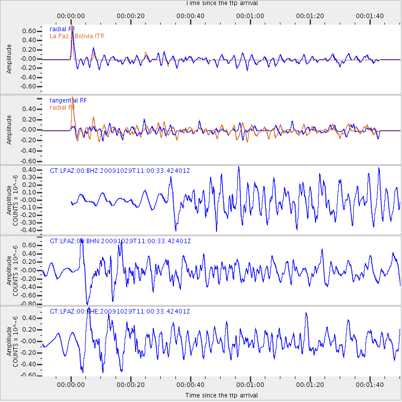
LPAZ La Paz , Bolivia - Earthquake Result Viewer
*The percent match for this event was below the threshold and hence no stack was calculated.
| Earthquake location: |
Veracruz, Mexico |
| Earthquake latitude/longitude: |
18.9/-95.5 |
| Earthquake time(UTC): |
2009/10/29 (302) 10:52:56 GMT |
| Earthquake Depth: |
16 km |
| Earthquake Magnitude: |
5.5 MB, 5.3 MS, 5.7 MW, 5.5 MD |
| Earthquake Catalog/Contributor: |
WHDF/NEIC |
|
| Network: |
GT Global Telemetered Seismograph Network (USAF/USGS) |
| Station: |
LPAZ La Paz , Bolivia |
| Lat/Lon: |
16.17 S/68.08 W |
| Elevation: |
4817 m |
|
| Distance: |
44.1 deg |
| Az: |
140.459 deg |
| Baz: |
321.156 deg |
| Ray Param: |
$rayparam |
*The percent match for this event was below the threshold and hence was not used in the summary stack. |
|
| Radial Match: |
77.36761 % |
| Radial Bump: |
400 |
| Transverse Match: |
69.085205 % |
| Transverse Bump: |
400 |
| SOD ConfigId: |
2622 |
| Insert Time: |
2010-02-27 02:12:17.221 +0000 |
| GWidth: |
2.5 |
| Max Bumps: |
400 |
| Tol: |
0.001 |
|
Signal To Noise
| Channel | StoN | STA | LTA |
| GT:LPAZ:00:BHN:20091029T11:00:33.42401Z | 4.8810997 | 3.057719E-7 | 6.2644055E-8 |
| GT:LPAZ:00:BHE:20091029T11:00:33.42401Z | 5.7700167 | 2.2927935E-7 | 3.9736342E-8 |
| GT:LPAZ:00:BHZ:20091029T11:00:33.42401Z | 2.5799317 | 1.1939731E-7 | 4.6279254E-8 |
| Arrivals |
| Ps | |
| PpPs | |
| PsPs/PpSs | |


