You are here: Home > Network List > GT - Global Telemetered Seismograph Network (USAF/USGS) Stations List
> Station LPAZ La Paz , Bolivia > Earthquake Result Viewer
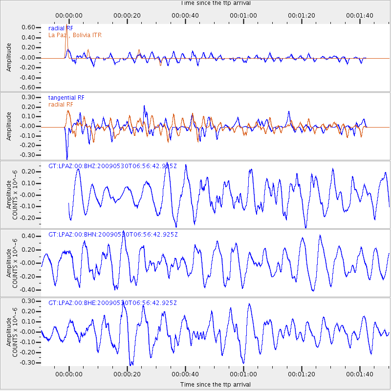
LPAZ La Paz , Bolivia - Earthquake Result Viewer
*The percent match for this event was below the threshold and hence no stack was calculated.
| Earthquake location: |
South Sandwich Islands Region |
| Earthquake latitude/longitude: |
-60.4/-26.1 |
| Earthquake time(UTC): |
2009/05/30 (150) 06:47:54 GMT |
| Earthquake Depth: |
10 km |
| Earthquake Magnitude: |
5.5 MW, 5.2 MS, 5.1 MB |
| Earthquake Catalog/Contributor: |
WHDF/NEIC |
|
| Network: |
GT Global Telemetered Seismograph Network (USAF/USGS) |
| Station: |
LPAZ La Paz , Bolivia |
| Lat/Lon: |
16.17 S/68.08 W |
| Elevation: |
4817 m |
|
| Distance: |
53.5 deg |
| Az: |
306.933 deg |
| Baz: |
155.627 deg |
| Ray Param: |
$rayparam |
*The percent match for this event was below the threshold and hence was not used in the summary stack. |
|
| Radial Match: |
55.06825 % |
| Radial Bump: |
400 |
| Transverse Match: |
68.571945 % |
| Transverse Bump: |
400 |
| SOD ConfigId: |
2648 |
| Insert Time: |
2010-02-27 02:12:22.320 +0000 |
| GWidth: |
2.5 |
| Max Bumps: |
400 |
| Tol: |
0.001 |
|
Signal To Noise
| Channel | StoN | STA | LTA |
| GT:LPAZ:00:BHN:20090530T06:56:42.925Z | 2.1258526 | 1.9769513E-7 | 9.299569E-8 |
| GT:LPAZ:00:BHE:20090530T06:56:42.925Z | 1.0562574 | 6.554042E-8 | 6.204967E-8 |
| GT:LPAZ:00:BHZ:20090530T06:56:42.925Z | 1.8644338 | 1.6415053E-7 | 8.80431E-8 |
| Arrivals |
| Ps | |
| PpPs | |
| PsPs/PpSs | |


