You are here: Home > Network List > GT - Global Telemetered Seismograph Network (USAF/USGS) Stations List
> Station LPAZ La Paz , Bolivia > Earthquake Result Viewer
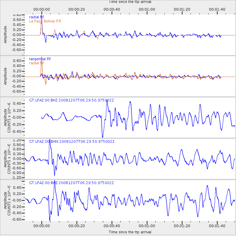
LPAZ La Paz , Bolivia - Earthquake Result Viewer
*The percent match for this event was below the threshold and hence no stack was calculated.
| Earthquake location: |
Northern Mid-Atlantic Ridge |
| Earthquake latitude/longitude: |
13.4/-44.8 |
| Earthquake time(UTC): |
2008/12/07 (342) 06:23:09 GMT |
| Earthquake Depth: |
10 km |
| Earthquake Magnitude: |
5.6 MB, 5.3 MS, 5.7 MW |
| Earthquake Catalog/Contributor: |
WHDF/NEIC |
|
| Network: |
GT Global Telemetered Seismograph Network (USAF/USGS) |
| Station: |
LPAZ La Paz , Bolivia |
| Lat/Lon: |
16.17 S/68.08 W |
| Elevation: |
4817 m |
|
| Distance: |
37.3 deg |
| Az: |
218.79 deg |
| Baz: |
39.387 deg |
| Ray Param: |
$rayparam |
*The percent match for this event was below the threshold and hence was not used in the summary stack. |
|
| Radial Match: |
74.717896 % |
| Radial Bump: |
400 |
| Transverse Match: |
69.616295 % |
| Transverse Bump: |
400 |
| SOD ConfigId: |
2658 |
| Insert Time: |
2010-02-27 02:12:27.735 +0000 |
| GWidth: |
2.5 |
| Max Bumps: |
400 |
| Tol: |
0.001 |
|
Signal To Noise
| Channel | StoN | STA | LTA |
| GT:LPAZ:00:BHN:20081207T06:29:50.975002Z | 5.2874837 | 3.9756432E-7 | 7.51897E-8 |
| GT:LPAZ:00:BHE:20081207T06:29:50.975002Z | 3.5191834 | 1.9615833E-7 | 5.573973E-8 |
| GT:LPAZ:00:BHZ:20081207T06:29:50.975002Z | 2.9314904 | 1.6978987E-7 | 5.7919298E-8 |
| Arrivals |
| Ps | |
| PpPs | |
| PsPs/PpSs | |


