You are here: Home > Network List > GT - Global Telemetered Seismograph Network (USAF/USGS) Stations List
> Station LPAZ La Paz , Bolivia > Earthquake Result Viewer
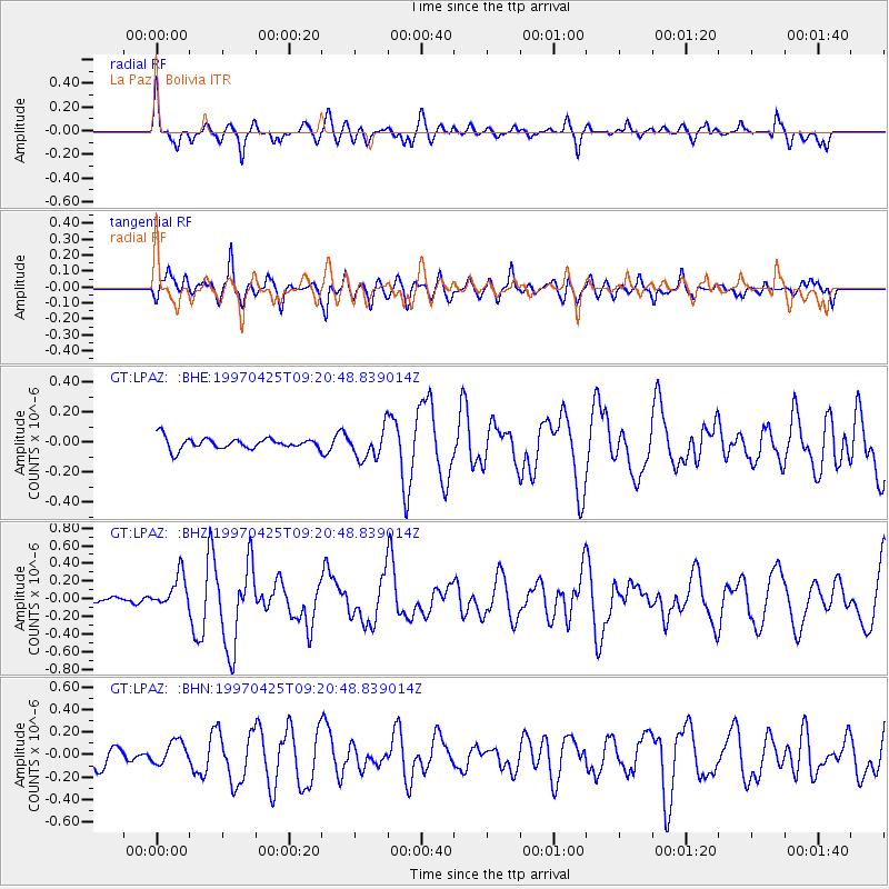
LPAZ La Paz , Bolivia - Earthquake Result Viewer
*The percent match for this event was below the threshold and hence no stack was calculated.
| Earthquake location: |
Southern Mid-Atlantic Ridge |
| Earthquake latitude/longitude: |
-48.3/-10.0 |
| Earthquake time(UTC): |
1997/04/25 (115) 09:11:34 GMT |
| Earthquake Depth: |
10 km |
| Earthquake Magnitude: |
5.8 MS, 5.3 MB, 5.8 UNKNOWN, 5.7 MW |
| Earthquake Catalog/Contributor: |
WHDF/NEIC |
|
| Network: |
GT Global Telemetered Seismograph Network (USAF/USGS) |
| Station: |
LPAZ La Paz , Bolivia |
| Lat/Lon: |
16.29 S/68.13 W |
| Elevation: |
4769 m |
|
| Distance: |
56.9 deg |
| Az: |
283.264 deg |
| Baz: |
137.455 deg |
| Ray Param: |
$rayparam |
*The percent match for this event was below the threshold and hence was not used in the summary stack. |
|
| Radial Match: |
67.3351 % |
| Radial Bump: |
400 |
| Transverse Match: |
68.29582 % |
| Transverse Bump: |
400 |
| SOD ConfigId: |
4480 |
| Insert Time: |
2010-02-27 02:12:35.586 +0000 |
| GWidth: |
2.5 |
| Max Bumps: |
400 |
| Tol: |
0.001 |
|
Signal To Noise
| Channel | StoN | STA | LTA |
| GT:LPAZ: :BHZ:19970425T09:20:48.839014Z | 2.4197876 | 1.925116E-7 | 7.955723E-8 |
| GT:LPAZ: :BHN:19970425T09:20:48.839014Z | 1.2683852 | 1.0355544E-7 | 8.164353E-8 |
| GT:LPAZ: :BHE:19970425T09:20:48.839014Z | 2.2476463 | 8.4145164E-8 | 3.743701E-8 |
| Arrivals |
| Ps | |
| PpPs | |
| PsPs/PpSs | |


