You are here: Home > Network List > GT - Global Telemetered Seismograph Network (USAF/USGS) Stations List
> Station LPAZ La Paz , Bolivia > Earthquake Result Viewer
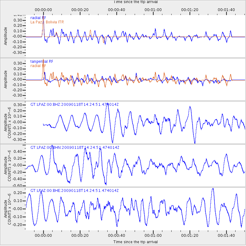
LPAZ La Paz , Bolivia - Earthquake Result Viewer
*The percent match for this event was below the threshold and hence no stack was calculated.
| Earthquake location: |
Kermadec Islands, New Zealand |
| Earthquake latitude/longitude: |
-30.2/-178.0 |
| Earthquake time(UTC): |
2009/01/18 (018) 14:11:48 GMT |
| Earthquake Depth: |
33 km |
| Earthquake Magnitude: |
6.0 MB, 6.1 MS, 6.4 MW, 6.4 MW |
| Earthquake Catalog/Contributor: |
WHDF/NEIC |
|
| Network: |
GT Global Telemetered Seismograph Network (USAF/USGS) |
| Station: |
LPAZ La Paz , Bolivia |
| Lat/Lon: |
16.17 S/68.08 W |
| Elevation: |
4817 m |
|
| Distance: |
98.3 deg |
| Az: |
114.041 deg |
| Baz: |
235.366 deg |
| Ray Param: |
$rayparam |
*The percent match for this event was below the threshold and hence was not used in the summary stack. |
|
| Radial Match: |
61.973774 % |
| Radial Bump: |
400 |
| Transverse Match: |
55.846737 % |
| Transverse Bump: |
363 |
| SOD ConfigId: |
2658 |
| Insert Time: |
2010-02-27 02:12:37.710 +0000 |
| GWidth: |
2.5 |
| Max Bumps: |
400 |
| Tol: |
0.001 |
|
Signal To Noise
| Channel | StoN | STA | LTA |
| GT:LPAZ:00:BHN:20090118T14:24:51.474014Z | 3.2357843 | 2.926026E-7 | 9.042711E-8 |
| GT:LPAZ:00:BHE:20090118T14:24:51.474014Z | 1.20805 | 1.1202921E-7 | 9.2735576E-8 |
| GT:LPAZ:00:BHZ:20090118T14:24:51.474014Z | 1.9333421 | 1.5198843E-7 | 7.861435E-8 |
| Arrivals |
| Ps | |
| PpPs | |
| PsPs/PpSs | |


