You are here: Home > Network List > GT - Global Telemetered Seismograph Network (USAF/USGS) Stations List
> Station LPAZ La Paz , Bolivia > Earthquake Result Viewer
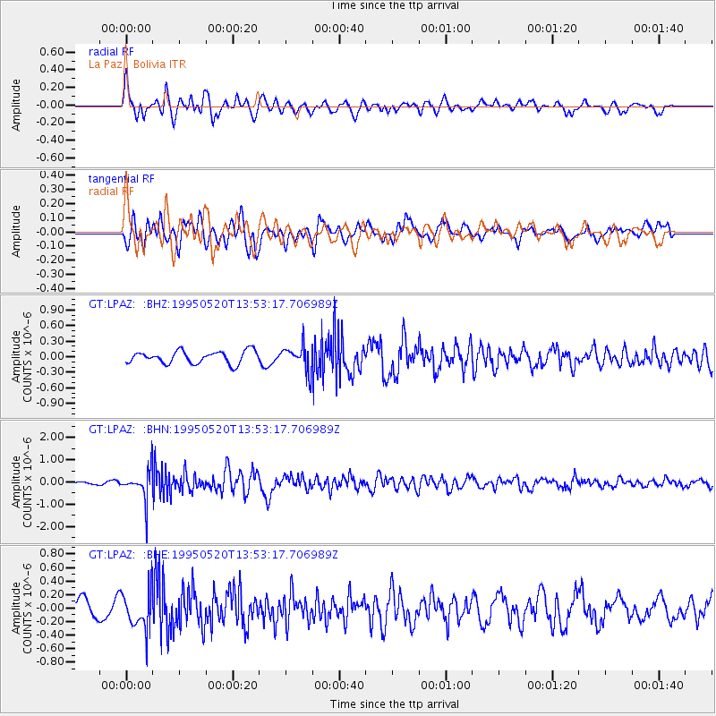
LPAZ La Paz , Bolivia - Earthquake Result Viewer
*The percent match for this event was below the threshold and hence no stack was calculated.
| Earthquake location: |
South Sandwich Islands Region |
| Earthquake latitude/longitude: |
-56.0/-27.7 |
| Earthquake time(UTC): |
1995/05/20 (140) 13:45:02 GMT |
| Earthquake Depth: |
100 km |
| Earthquake Magnitude: |
5.5 MB, 5.5 UNKNOWN |
| Earthquake Catalog/Contributor: |
WHDF/NEIC |
|
| Network: |
GT Global Telemetered Seismograph Network (USAF/USGS) |
| Station: |
LPAZ La Paz , Bolivia |
| Lat/Lon: |
16.29 S/68.13 W |
| Elevation: |
4769 m |
|
| Distance: |
50.1 deg |
| Az: |
305.775 deg |
| Baz: |
151.675 deg |
| Ray Param: |
$rayparam |
*The percent match for this event was below the threshold and hence was not used in the summary stack. |
|
| Radial Match: |
63.10752 % |
| Radial Bump: |
400 |
| Transverse Match: |
64.953186 % |
| Transverse Bump: |
400 |
| SOD ConfigId: |
4480 |
| Insert Time: |
2010-02-27 02:12:38.998 +0000 |
| GWidth: |
2.5 |
| Max Bumps: |
400 |
| Tol: |
0.001 |
|
Signal To Noise
| Channel | StoN | STA | LTA |
| GT:LPAZ: :BHN:19950520T13:53:17.706989Z | 7.942602 | 6.739875E-7 | 8.4857255E-8 |
| GT:LPAZ: :BHE:19950520T13:53:17.706989Z | 1.8498527 | 2.9327788E-7 | 1.5854121E-7 |
| GT:LPAZ: :BHZ:19950520T13:53:17.706989Z | 1.4887367 | 1.7951469E-7 | 1.2058189E-7 |
| Arrivals |
| Ps | |
| PpPs | |
| PsPs/PpSs | |


