You are here: Home > Network List > GT - Global Telemetered Seismograph Network (USAF/USGS) Stations List
> Station LPAZ La Paz , Bolivia > Earthquake Result Viewer
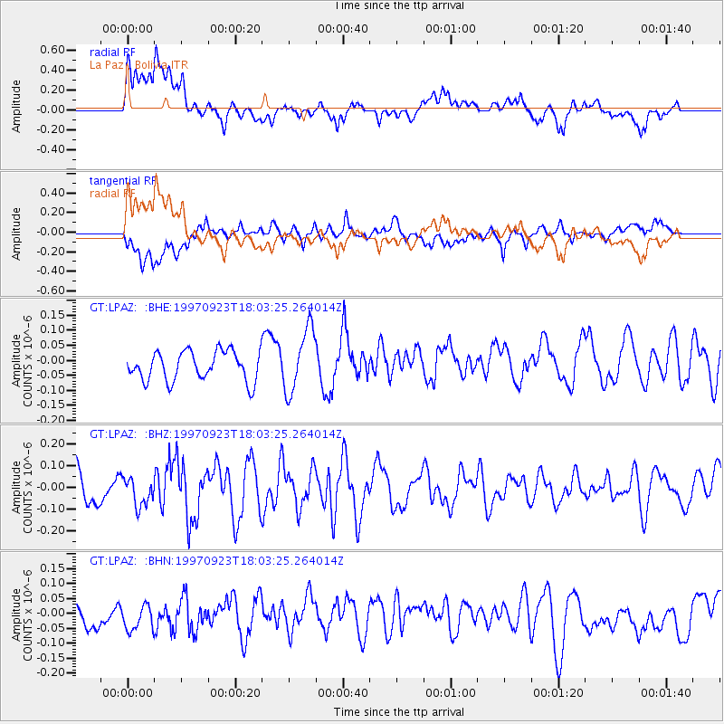
LPAZ La Paz , Bolivia - Earthquake Result Viewer
*The percent match for this event was below the threshold and hence no stack was calculated.
| Earthquake location: |
Balleny Islands Region |
| Earthquake latitude/longitude: |
-65.5/178.8 |
| Earthquake time(UTC): |
1997/09/23 (266) 17:51:23 GMT |
| Earthquake Depth: |
10 km |
| Earthquake Magnitude: |
5.9 MS, 5.0 MB |
| Earthquake Catalog/Contributor: |
WHDF/NEIC |
|
| Network: |
GT Global Telemetered Seismograph Network (USAF/USGS) |
| Station: |
LPAZ La Paz , Bolivia |
| Lat/Lon: |
16.29 S/68.13 W |
| Elevation: |
4769 m |
|
| Distance: |
84.5 deg |
| Az: |
117.4 deg |
| Baz: |
202.651 deg |
| Ray Param: |
$rayparam |
*The percent match for this event was below the threshold and hence was not used in the summary stack. |
|
| Radial Match: |
47.272926 % |
| Radial Bump: |
400 |
| Transverse Match: |
47.27139 % |
| Transverse Bump: |
400 |
| SOD ConfigId: |
4480 |
| Insert Time: |
2010-02-27 02:12:42.341 +0000 |
| GWidth: |
2.5 |
| Max Bumps: |
400 |
| Tol: |
0.001 |
|
Signal To Noise
| Channel | StoN | STA | LTA |
| GT:LPAZ: :BHZ:19970923T18:03:25.264014Z | 0.92682725 | 6.665582E-8 | 7.1918286E-8 |
| GT:LPAZ: :BHN:19970923T18:03:25.264014Z | 1.0203084 | 9.09682E-8 | 8.915755E-8 |
| GT:LPAZ: :BHE:19970923T18:03:25.264014Z | 2.1202145 | 1.0191393E-7 | 4.8067747E-8 |
| Arrivals |
| Ps | |
| PpPs | |
| PsPs/PpSs | |


