You are here: Home > Network List > GT - Global Telemetered Seismograph Network (USAF/USGS) Stations List
> Station LPAZ La Paz , Bolivia > Earthquake Result Viewer
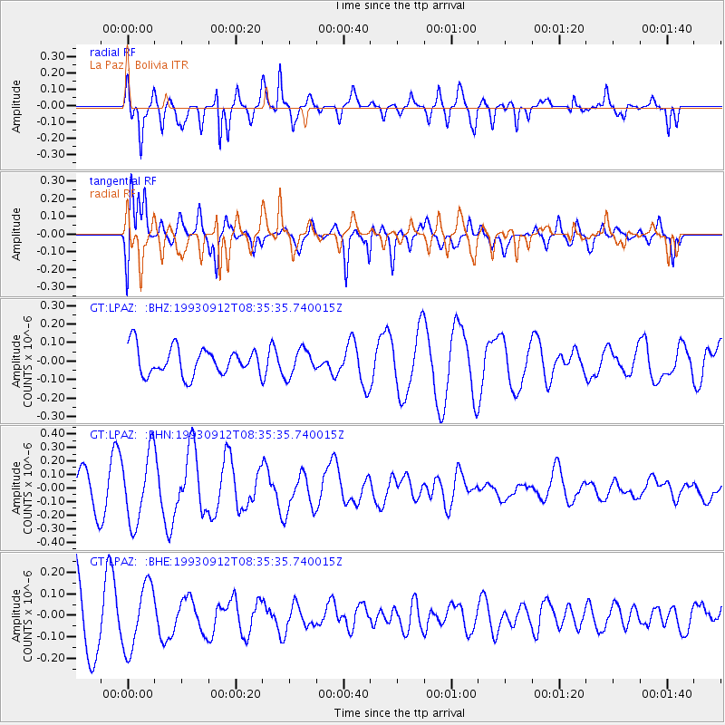
LPAZ La Paz , Bolivia - Earthquake Result Viewer
*The percent match for this event was below the threshold and hence no stack was calculated.
| Earthquake location: |
Kermadec Islands, New Zealand |
| Earthquake latitude/longitude: |
-29.5/-177.2 |
| Earthquake time(UTC): |
1993/09/12 (255) 08:22:34 GMT |
| Earthquake Depth: |
33 km |
| Earthquake Magnitude: |
5.5 MB, 5.8 MS, 6.0 UNKNOWN, 6.2 MW |
| Earthquake Catalog/Contributor: |
WHDF/NEIC |
|
| Network: |
GT Global Telemetered Seismograph Network (USAF/USGS) |
| Station: |
LPAZ La Paz , Bolivia |
| Lat/Lon: |
16.29 S/68.13 W |
| Elevation: |
4769 m |
|
| Distance: |
97.9 deg |
| Az: |
113.605 deg |
| Baz: |
236.262 deg |
| Ray Param: |
$rayparam |
*The percent match for this event was below the threshold and hence was not used in the summary stack. |
|
| Radial Match: |
76.22021 % |
| Radial Bump: |
400 |
| Transverse Match: |
44.71655 % |
| Transverse Bump: |
400 |
| SOD ConfigId: |
4480 |
| Insert Time: |
2010-02-27 02:12:46.266 +0000 |
| GWidth: |
2.5 |
| Max Bumps: |
400 |
| Tol: |
0.001 |
|
Signal To Noise
| Channel | StoN | STA | LTA |
| GT:LPAZ: :BHN:19930912T08:35:35.740015Z | 2.9397085 | 2.5735565E-7 | 8.754461E-8 |
| GT:LPAZ: :BHE:19930912T08:35:35.740015Z | 0.91527426 | 1.5276595E-7 | 1.669073E-7 |
| GT:LPAZ: :BHZ:19930912T08:35:35.740015Z | 0.9971656 | 7.3862104E-8 | 7.407205E-8 |
| Arrivals |
| Ps | |
| PpPs | |
| PsPs/PpSs | |


