You are here: Home > Network List > GT - Global Telemetered Seismograph Network (USAF/USGS) Stations List
> Station LPAZ La Paz , Bolivia > Earthquake Result Viewer
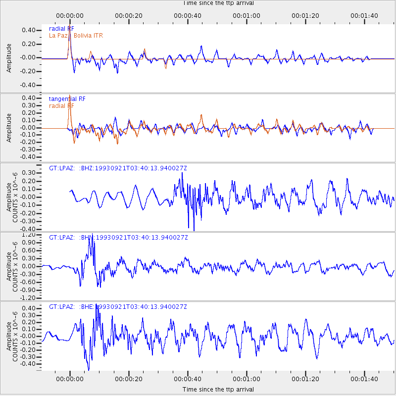
LPAZ La Paz , Bolivia - Earthquake Result Viewer
*The percent match for this event was below the threshold and hence no stack was calculated.
| Earthquake location: |
Oregon |
| Earthquake latitude/longitude: |
42.3/-122.0 |
| Earthquake time(UTC): |
1993/09/21 (264) 03:28:55 GMT |
| Earthquake Depth: |
11 km |
| Earthquake Magnitude: |
5.8 MB, 5.8 MS, 5.9 UNKNOWN, 5.9 ML |
| Earthquake Catalog/Contributor: |
WHDF/NEIC |
|
| Network: |
GT Global Telemetered Seismograph Network (USAF/USGS) |
| Station: |
LPAZ La Paz , Bolivia |
| Lat/Lon: |
16.29 S/68.13 W |
| Elevation: |
4769 m |
|
| Distance: |
76.5 deg |
| Az: |
127.092 deg |
| Baz: |
321.97 deg |
| Ray Param: |
$rayparam |
*The percent match for this event was below the threshold and hence was not used in the summary stack. |
|
| Radial Match: |
77.006935 % |
| Radial Bump: |
400 |
| Transverse Match: |
56.165886 % |
| Transverse Bump: |
400 |
| SOD ConfigId: |
4480 |
| Insert Time: |
2010-02-27 02:12:47.464 +0000 |
| GWidth: |
2.5 |
| Max Bumps: |
400 |
| Tol: |
0.001 |
|
Signal To Noise
| Channel | StoN | STA | LTA |
| GT:LPAZ: :BHN:19930921T03:40:13.940027Z | 5.002414 | 2.4626323E-7 | 4.9228873E-8 |
| GT:LPAZ: :BHE:19930921T03:40:13.940027Z | 1.3580279 | 1.2027019E-7 | 8.856238E-8 |
| GT:LPAZ: :BHZ:19930921T03:40:13.940027Z | 0.8194148 | 5.624472E-8 | 6.8640105E-8 |
| Arrivals |
| Ps | |
| PpPs | |
| PsPs/PpSs | |


