You are here: Home > Network List > GT - Global Telemetered Seismograph Network (USAF/USGS) Stations List
> Station LPAZ La Paz , Bolivia > Earthquake Result Viewer
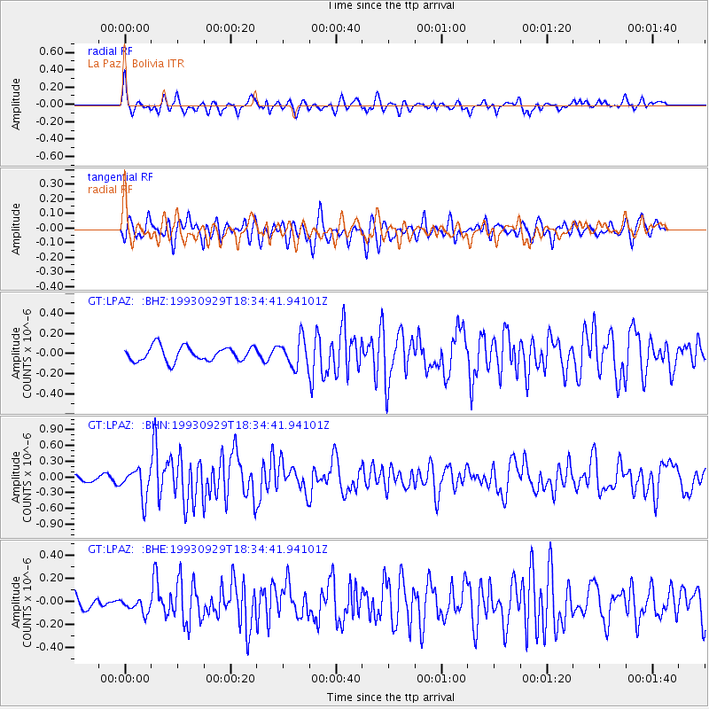
LPAZ La Paz , Bolivia - Earthquake Result Viewer
*The percent match for this event was below the threshold and hence no stack was calculated.
| Earthquake location: |
Southern Mid-Atlantic Ridge |
| Earthquake latitude/longitude: |
-42.6/-18.4 |
| Earthquake time(UTC): |
1993/09/29 (272) 18:26:20 GMT |
| Earthquake Depth: |
10 km |
| Earthquake Magnitude: |
5.7 MB, 5.9 MS |
| Earthquake Catalog/Contributor: |
WHDF/NEIC |
|
| Network: |
GT Global Telemetered Seismograph Network (USAF/USGS) |
| Station: |
LPAZ La Paz , Bolivia |
| Lat/Lon: |
16.29 S/68.13 W |
| Elevation: |
4769 m |
|
| Distance: |
49.7 deg |
| Az: |
286.2 deg |
| Baz: |
132.384 deg |
| Ray Param: |
$rayparam |
*The percent match for this event was below the threshold and hence was not used in the summary stack. |
|
| Radial Match: |
67.97312 % |
| Radial Bump: |
400 |
| Transverse Match: |
64.57738 % |
| Transverse Bump: |
400 |
| SOD ConfigId: |
4480 |
| Insert Time: |
2010-02-27 02:12:49.908 +0000 |
| GWidth: |
2.5 |
| Max Bumps: |
400 |
| Tol: |
0.001 |
|
Signal To Noise
| Channel | StoN | STA | LTA |
| GT:LPAZ: :BHN:19930929T18:34:41.94101Z | 5.1701427 | 2.8439234E-7 | 5.5006673E-8 |
| GT:LPAZ: :BHE:19930929T18:34:41.94101Z | 0.9885248 | 6.219166E-8 | 6.29136E-8 |
| GT:LPAZ: :BHZ:19930929T18:34:41.94101Z | 1.8940343 | 1.3645491E-7 | 7.2044585E-8 |
| Arrivals |
| Ps | |
| PpPs | |
| PsPs/PpSs | |


