You are here: Home > Network List > GT - Global Telemetered Seismograph Network (USAF/USGS) Stations List
> Station LPAZ La Paz , Bolivia > Earthquake Result Viewer
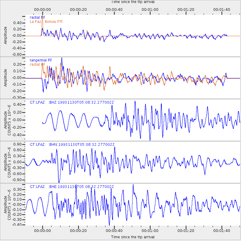
LPAZ La Paz , Bolivia - Earthquake Result Viewer
*The percent match for this event was below the threshold and hence no stack was calculated.
| Earthquake location: |
Southwestern Atlantic Ocean |
| Earthquake latitude/longitude: |
-59.1/-18.1 |
| Earthquake time(UTC): |
1993/11/30 (334) 04:59:26 GMT |
| Earthquake Depth: |
33 km |
| Earthquake Magnitude: |
5.5 MS, 5.2 MB |
| Earthquake Catalog/Contributor: |
WHDF/NEIC |
|
| Network: |
GT Global Telemetered Seismograph Network (USAF/USGS) |
| Station: |
LPAZ La Paz , Bolivia |
| Lat/Lon: |
16.29 S/68.13 W |
| Elevation: |
4769 m |
|
| Distance: |
56.1 deg |
| Az: |
297.648 deg |
| Baz: |
151.609 deg |
| Ray Param: |
$rayparam |
*The percent match for this event was below the threshold and hence was not used in the summary stack. |
|
| Radial Match: |
55.9845 % |
| Radial Bump: |
400 |
| Transverse Match: |
71.07842 % |
| Transverse Bump: |
400 |
| SOD ConfigId: |
4480 |
| Insert Time: |
2010-02-27 02:12:55.021 +0000 |
| GWidth: |
2.5 |
| Max Bumps: |
400 |
| Tol: |
0.001 |
|
Signal To Noise
| Channel | StoN | STA | LTA |
| GT:LPAZ: :BHN:19931130T05:08:32.277002Z | 0.4588954 | 7.489326E-8 | 1.6320334E-7 |
| GT:LPAZ: :BHE:19931130T05:08:32.277002Z | 1.5167581 | 1.6776993E-7 | 1.1061086E-7 |
| GT:LPAZ: :BHZ:19931130T05:08:32.277002Z | 0.6847128 | 1.0466238E-7 | 1.5285588E-7 |
| Arrivals |
| Ps | |
| PpPs | |
| PsPs/PpSs | |


