You are here: Home > Network List > TA - USArray Transportable Network (new EarthScope stations) Stations List
> Station N46A Monticello, IN, USA > Earthquake Result Viewer
N46A Monticello, IN, USA - Earthquake Result Viewer
*The percent match for this event was below the threshold and hence no stack was calculated.
| Earthquake location: |
Leeward Islands |
| Earthquake latitude/longitude: |
18.0/-59.8 |
| Earthquake time(UTC): |
2011/12/03 (337) 09:27:11 GMT |
| Earthquake Depth: |
10 km |
| Earthquake Magnitude: |
5.6 MW, 5.2 MS, 5.4 MB, 5.6 MW |
| Earthquake Catalog/Contributor: |
WHDF/NEIC |
|
| Network: |
TA USArray Transportable Network (new EarthScope stations) |
| Station: |
N46A Monticello, IN, USA |
| Lat/Lon: |
40.89 N/86.74 W |
| Elevation: |
209 m |
|
| Distance: |
32.5 deg |
| Az: |
320.311 deg |
| Baz: |
126.686 deg |
| Ray Param: |
$rayparam |
*The percent match for this event was below the threshold and hence was not used in the summary stack. |
|
| Radial Match: |
65.32805 % |
| Radial Bump: |
391 |
| Transverse Match: |
54.95298 % |
| Transverse Bump: |
400 |
| SOD ConfigId: |
510410 |
| Insert Time: |
2013-09-04 20:29:19.041 +0000 |
| GWidth: |
2.5 |
| Max Bumps: |
400 |
| Tol: |
0.001 |
|
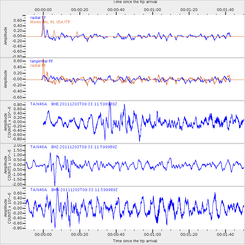
Signal To Noise
| Channel | StoN | STA | LTA |
| TA:N46A: :BHZ:20111203T09:33:11.599989Z | 1.8946539 | 4.4521377E-7 | 2.3498423E-7 |
| TA:N46A: :BHN:20111203T09:33:11.599989Z | 1.5339911 | 2.6526735E-7 | 1.7292625E-7 |
| TA:N46A: :BHE:20111203T09:33:11.599989Z | 1.6598222 | 2.8952616E-7 | 1.7443203E-7 |
| Arrivals |
| Ps | |
| PpPs | |
| PsPs/PpSs | |


