You are here: Home > Network List > GT - Global Telemetered Seismograph Network (USAF/USGS) Stations List
> Station LPAZ La Paz , Bolivia > Earthquake Result Viewer
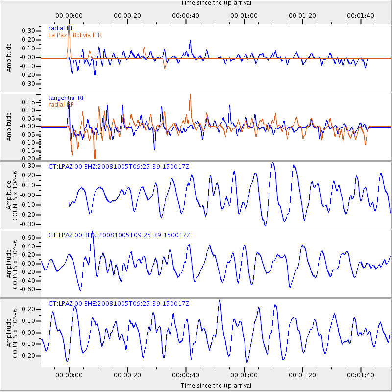
LPAZ La Paz , Bolivia - Earthquake Result Viewer
*The percent match for this event was below the threshold and hence no stack was calculated.
| Earthquake location: |
Kermadec Islands, New Zealand |
| Earthquake latitude/longitude: |
-30.2/-177.2 |
| Earthquake time(UTC): |
2008/10/05 (279) 09:12:36 GMT |
| Earthquake Depth: |
10 km |
| Earthquake Magnitude: |
5.8 MB, 6.2 MS, 6.2 MW, 6.1 MW |
| Earthquake Catalog/Contributor: |
WHDF/NEIC |
|
| Network: |
GT Global Telemetered Seismograph Network (USAF/USGS) |
| Station: |
LPAZ La Paz , Bolivia |
| Lat/Lon: |
16.17 S/68.08 W |
| Elevation: |
4817 m |
|
| Distance: |
97.7 deg |
| Az: |
113.613 deg |
| Baz: |
235.653 deg |
| Ray Param: |
$rayparam |
*The percent match for this event was below the threshold and hence was not used in the summary stack. |
|
| Radial Match: |
44.79789 % |
| Radial Bump: |
400 |
| Transverse Match: |
35.12386 % |
| Transverse Bump: |
334 |
| SOD ConfigId: |
2556 |
| Insert Time: |
2010-02-27 02:12:58.970 +0000 |
| GWidth: |
2.5 |
| Max Bumps: |
400 |
| Tol: |
0.001 |
|
Signal To Noise
| Channel | StoN | STA | LTA |
| GT:LPAZ:00:BHN:20081005T09:25:39.150017Z | 2.6624923 | 3.1153894E-7 | 1.1701027E-7 |
| GT:LPAZ:00:BHE:20081005T09:25:39.150017Z | 1.438956 | 1.6799977E-7 | 1.1675115E-7 |
| GT:LPAZ:00:BHZ:20081005T09:25:39.150017Z | 1.5804329 | 1.17757345E-7 | 7.450955E-8 |
| Arrivals |
| Ps | |
| PpPs | |
| PsPs/PpSs | |


