You are here: Home > Network List > TA - USArray Transportable Network (new EarthScope stations) Stations List
> Station MSTX Muleshoe, TX, USA > Earthquake Result Viewer
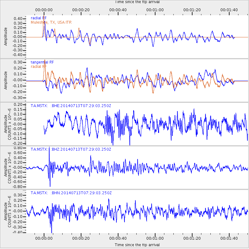
MSTX Muleshoe, TX, USA - Earthquake Result Viewer
*The percent match for this event was below the threshold and hence no stack was calculated.
| Earthquake location: |
Chile-Argentina Border Region |
| Earthquake latitude/longitude: |
-30.6/-70.5 |
| Earthquake time(UTC): |
2014/07/13 (194) 07:18:25 GMT |
| Earthquake Depth: |
91 km |
| Earthquake Magnitude: |
5.4 MW, 5.2 mb |
| Earthquake Catalog/Contributor: |
ISC/ISC |
|
| Network: |
TA USArray Transportable Network (new EarthScope stations) |
| Station: |
MSTX Muleshoe, TX, USA |
| Lat/Lon: |
33.97 N/102.77 W |
| Elevation: |
1167 m |
|
| Distance: |
71.1 deg |
| Az: |
331.991 deg |
| Baz: |
150.846 deg |
| Ray Param: |
$rayparam |
*The percent match for this event was below the threshold and hence was not used in the summary stack. |
|
| Radial Match: |
70.01176 % |
| Radial Bump: |
400 |
| Transverse Match: |
41.492855 % |
| Transverse Bump: |
400 |
| SOD ConfigId: |
3390531 |
| Insert Time: |
2019-04-12 20:00:20.282 +0000 |
| GWidth: |
2.5 |
| Max Bumps: |
400 |
| Tol: |
0.001 |
|
Signal To Noise
| Channel | StoN | STA | LTA |
| TA:MSTX: :BHZ:20140713T07:29:03.250Z | 8.387411 | 2.6047292E-7 | 3.105522E-8 |
| TA:MSTX: :BHN:20140713T07:29:03.250Z | 2.6429577 | 1.16002774E-7 | 4.389127E-8 |
| TA:MSTX: :BHE:20140713T07:29:03.250Z | 1.0103844 | 6.246075E-8 | 6.1818795E-8 |
| Arrivals |
| Ps | |
| PpPs | |
| PsPs/PpSs | |


