You are here: Home > Network List > GT - Global Telemetered Seismograph Network (USAF/USGS) Stations List
> Station LPAZ La Paz , Bolivia > Earthquake Result Viewer
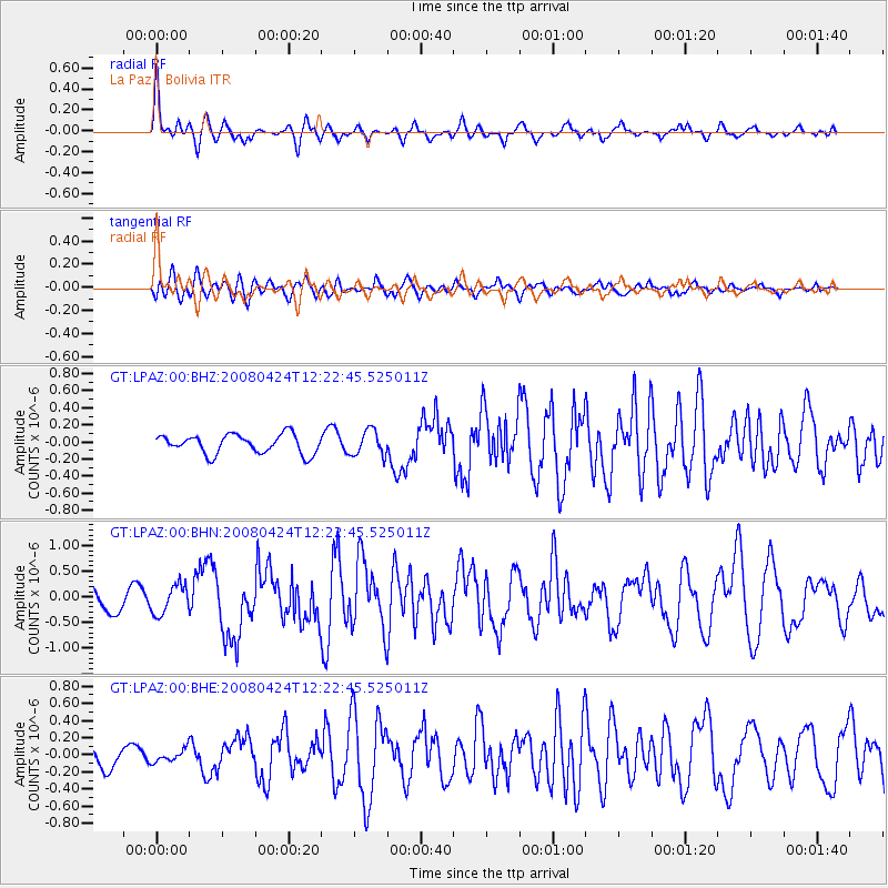
LPAZ La Paz , Bolivia - Earthquake Result Viewer
*The percent match for this event was below the threshold and hence no stack was calculated.
| Earthquake location: |
Central Mid-Atlantic Ridge |
| Earthquake latitude/longitude: |
-1.2/-23.5 |
| Earthquake time(UTC): |
2008/04/24 (115) 12:14:49 GMT |
| Earthquake Depth: |
10 km |
| Earthquake Magnitude: |
6.0 MS, 5.4 MB, 6.5 MW, 6.4 MW |
| Earthquake Catalog/Contributor: |
WHDF/NEIC |
|
| Network: |
GT Global Telemetered Seismograph Network (USAF/USGS) |
| Station: |
LPAZ La Paz , Bolivia |
| Lat/Lon: |
16.17 S/68.08 W |
| Elevation: |
4817 m |
|
| Distance: |
46.4 deg |
| Az: |
248.726 deg |
| Baz: |
75.824 deg |
| Ray Param: |
$rayparam |
*The percent match for this event was below the threshold and hence was not used in the summary stack. |
|
| Radial Match: |
79.752655 % |
| Radial Bump: |
381 |
| Transverse Match: |
73.17739 % |
| Transverse Bump: |
400 |
| SOD ConfigId: |
2504 |
| Insert Time: |
2010-02-27 02:13:10.211 +0000 |
| GWidth: |
2.5 |
| Max Bumps: |
400 |
| Tol: |
0.001 |
|
Signal To Noise
| Channel | StoN | STA | LTA |
| GT:LPAZ:00:BHN:20080424T12:22:45.525011Z | 1.4357373 | 2.807849E-7 | 1.9556845E-7 |
| GT:LPAZ:00:BHE:20080424T12:22:45.525011Z | 0.73038894 | 7.2120685E-8 | 9.8742845E-8 |
| GT:LPAZ:00:BHZ:20080424T12:22:45.525011Z | 1.3124844 | 1.4635721E-7 | 1.1151159E-7 |
| Arrivals |
| Ps | |
| PpPs | |
| PsPs/PpSs | |


