You are here: Home > Network List > GT - Global Telemetered Seismograph Network (USAF/USGS) Stations List
> Station LPAZ La Paz , Bolivia > Earthquake Result Viewer
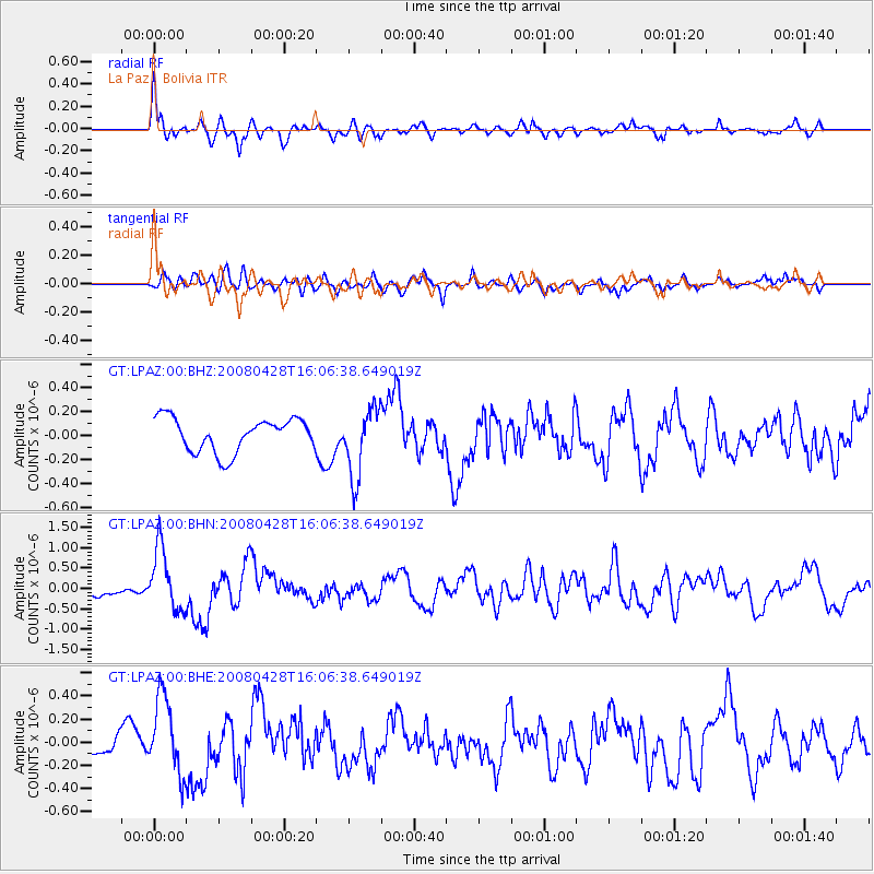
LPAZ La Paz , Bolivia - Earthquake Result Viewer
*The percent match for this event was below the threshold and hence no stack was calculated.
| Earthquake location: |
South Sandwich Islands Region |
| Earthquake latitude/longitude: |
-58.7/-24.7 |
| Earthquake time(UTC): |
2008/04/28 (119) 15:57:55 GMT |
| Earthquake Depth: |
35 km |
| Earthquake Magnitude: |
5.5 MB, 5.9 MS, 6.1 MW, 6.0 MW |
| Earthquake Catalog/Contributor: |
WHDF/NEIC |
|
| Network: |
GT Global Telemetered Seismograph Network (USAF/USGS) |
| Station: |
LPAZ La Paz , Bolivia |
| Lat/Lon: |
16.17 S/68.08 W |
| Elevation: |
4817 m |
|
| Distance: |
53.1 deg |
| Az: |
304.397 deg |
| Baz: |
153.397 deg |
| Ray Param: |
$rayparam |
*The percent match for this event was below the threshold and hence was not used in the summary stack. |
|
| Radial Match: |
71.625626 % |
| Radial Bump: |
400 |
| Transverse Match: |
58.452152 % |
| Transverse Bump: |
400 |
| SOD ConfigId: |
2504 |
| Insert Time: |
2010-02-27 02:13:11.804 +0000 |
| GWidth: |
2.5 |
| Max Bumps: |
400 |
| Tol: |
0.001 |
|
Signal To Noise
| Channel | StoN | STA | LTA |
| GT:LPAZ:00:BHN:20080428T16:06:38.649019Z | 4.4158926 | 7.536531E-7 | 1.7066836E-7 |
| GT:LPAZ:00:BHE:20080428T16:06:38.649019Z | 2.047192 | 3.3078686E-7 | 1.6158077E-7 |
| GT:LPAZ:00:BHZ:20080428T16:06:38.649019Z | 2.0478244 | 2.8697517E-7 | 1.4013659E-7 |
| Arrivals |
| Ps | |
| PpPs | |
| PsPs/PpSs | |


