You are here: Home > Network List > GT - Global Telemetered Seismograph Network (USAF/USGS) Stations List
> Station PLCA Paso Flores, Argentina > Earthquake Result Viewer
PLCA Paso Flores, Argentina - Earthquake Result Viewer
| Earthquake location: |
Colombia |
| Earthquake latitude/longitude: |
5.1/-75.7 |
| Earthquake time(UTC): |
1995/08/19 (231) 21:43:32 GMT |
| Earthquake Depth: |
125 km |
| Earthquake Magnitude: |
6.1 MB, 6.6 UNKNOWN, 6.5 MW |
| Earthquake Catalog/Contributor: |
WHDF/NEIC |
|
| Network: |
GT Global Telemetered Seismograph Network (USAF/USGS) |
| Station: |
PLCA Paso Flores, Argentina |
| Lat/Lon: |
40.73 S/70.55 W |
| Elevation: |
1050 m |
|
| Distance: |
45.8 deg |
| Az: |
174.556 deg |
| Baz: |
352.856 deg |
| Ray Param: |
0.0705839 |
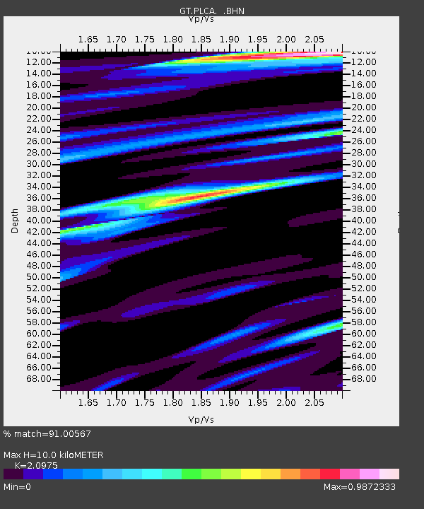
| Estimated Moho Depth: |
10.0 km |
| Estimated Crust Vp/Vs: |
2.10 |
| Assumed Crust Vp: |
6.597 km/s |
| Estimated Crust Vs: |
3.145 km/s |
| Estimated Crust Poisson's Ratio: |
0.35 |
|
| Radial Match: |
91.00567 % |
| Radial Bump: |
375 |
| Transverse Match: |
76.46652 % |
| Transverse Bump: |
400 |
| SOD ConfigId: |
6273 |
| Insert Time: |
2010-02-27 02:13:23.038 +0000 |
| GWidth: |
2.5 |
| Max Bumps: |
400 |
| Tol: |
0.001 |
|

Signal To Noise
| Channel | StoN | STA | LTA |
| GT:PLCA: :BHN:19950819T21:51:11.527014Z | 7.4064817 | 1.4819694E-6 | 2.0009087E-7 |
| GT:PLCA: :BHE:19950819T21:51:11.527014Z | 0.98150367 | 2.7635855E-7 | 2.8156649E-7 |
| GT:PLCA: :BHZ:19950819T21:51:11.527014Z | 4.930072 | 2.4836586E-6 | 5.0377736E-7 |
| Arrivals |
| Ps | 1.8 SECOND |
| PpPs | 4.4 SECOND |
| PsPs/PpSs | 6.2 SECOND |


