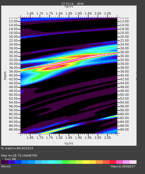
PLCA Paso Flores, Argentina - Earthquake Result Viewer
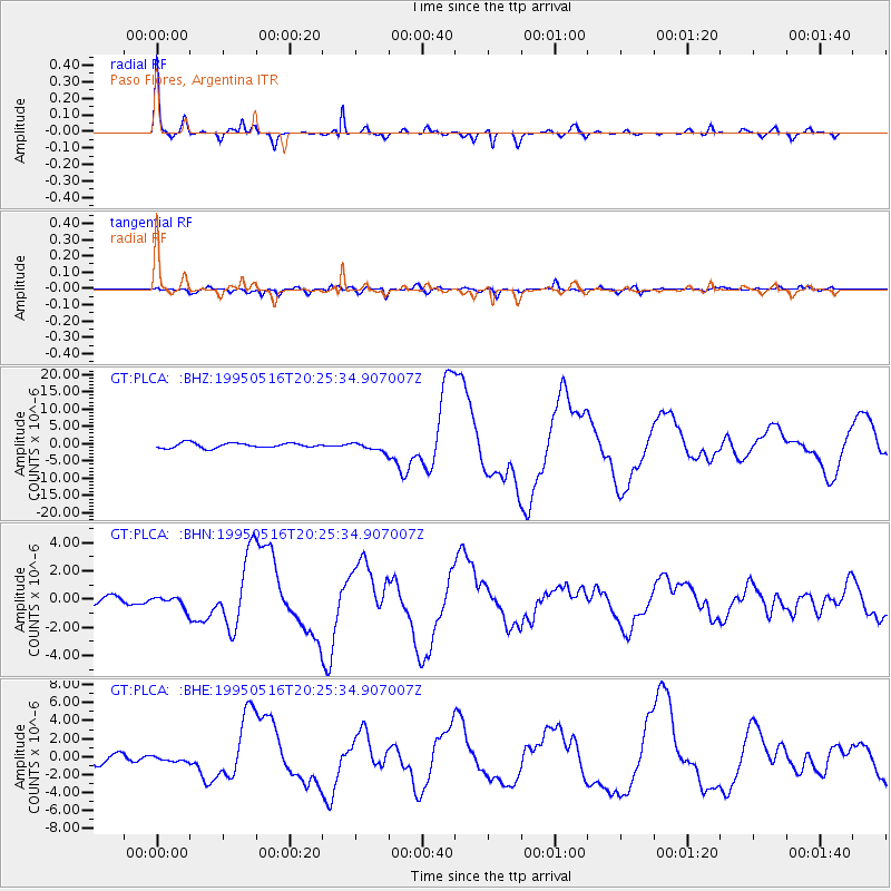
Earthquake location: Southeast Of Loyalty Islands
Earthquake latitude/longitude: -23.0/169.9
Earthquake time(UTC): 1995/05/16 (136) 20:12:45 GMT
Earthquake Depth: 33 km
Earthquake Magnitude: 6.8 MB, 7.7 MS, 7.7 UNKNOWN, 7.7 MW
Earthquake Catalog/Contributor: WHDF/NEIC
Network: GT Global Telemetered Seismograph Network (USAF/USGS)
Station: PLCA Paso Flores, Argentina
Lat/Lon: 40.73 S/70.55 W
Elevation: 1050 m
Distance: 95.3 deg
Az: 138.402 deg
Baz: 233.603 deg
Ray Param: 0.040799696
Estimated Moho Depth: 29.75 km
Estimated Crust Vp/Vs: 1.99
Assumed Crust Vp: 6.597 km/s
Estimated Crust Vs: 3.315 km/s
Estimated Crust Poisson's Ratio: 0.33
Radial Match: 96.902824 %
Radial Bump: 262
Transverse Match: 86.21405 %
Transverse Bump: 400
SOD ConfigId: 6273
Insert Time: 2010-02-27 02:13:25.001 +0000
GWidth: 2.5
Max Bumps: 400
Tol: 0.001

Signal To Noise

ChannelStoNSTALTA
GT:PLCA: :BHN:19950516T20:25:34.907007Z1.46481444.1918642E-72.8617032E-7
GT:PLCA: :BHE:19950516T20:25:34.907007Z0.50083093.1479576E-76.2854707E-7
GT:PLCA: :BHZ:19950516T20:25:34.907007Z1.77835351.2409628E-66.978156E-7
Arrivals
Ps4.5 SECOND
PpPs13 SECOND
PsPs/PpSs18 SECOND