You are here: Home > Network List > GT - Global Telemetered Seismograph Network (USAF/USGS) Stations List
> Station PLCA Paso Flores, Argentina > Earthquake Result Viewer
PLCA Paso Flores, Argentina - Earthquake Result Viewer

| Earthquake location: |
Leeward Islands |
| Earthquake latitude/longitude: |
16.6/-59.6 |
| Earthquake time(UTC): |
1995/03/08 (067) 03:45:59 GMT |
| Earthquake Depth: |
15 km |
| Earthquake Magnitude: |
6.3 MB, 6.2 MS, 6.4 UNKNOWN, 6.1 MD |
| Earthquake Catalog/Contributor: |
WHDF/NEIC |
|
| Network: |
GT Global Telemetered Seismograph Network (USAF/USGS) |
| Station: |
PLCA Paso Flores, Argentina |
| Lat/Lon: |
40.73 S/70.55 W |
| Elevation: |
1050 m |
|
| Distance: |
57.9 deg |
| Az: |
189.835 deg |
| Baz: |
12.449 deg |
| Ray Param: |
0.06318412 |
| Estimated Moho Depth: |
64.75 km |
| Estimated Crust Vp/Vs: |
1.83 |
| Assumed Crust Vp: |
6.597 km/s |
| Estimated Crust Vs: |
3.605 km/s |
| Estimated Crust Poisson's Ratio: |
0.29 |
|
| Radial Match: |
85.73867 % |
| Radial Bump: |
315 |
| Transverse Match: |
64.7553 % |
| Transverse Bump: |
400 |
| SOD ConfigId: |
6273 |
| Insert Time: |
2010-02-27 02:13:31.133 +0000 |
| GWidth: |
2.5 |
| Max Bumps: |
400 |
| Tol: |
0.001 |
|
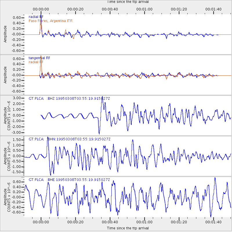
Signal To Noise
| Channel | StoN | STA | LTA |
| GT:PLCA: :BHN:19950308T03:55:19.915027Z | 3.864499 | 6.4688714E-7 | 1.6739224E-7 |
| GT:PLCA: :BHE:19950308T03:55:19.915027Z | 0.8928125 | 3.143455E-7 | 3.5208458E-7 |
| GT:PLCA: :BHZ:19950308T03:55:19.915027Z | 4.018501 | 1.1105482E-6 | 2.7635883E-7 |
| Arrivals |
| Ps | 8.6 SECOND |
| PpPs | 26 SECOND |
| PsPs/PpSs | 35 SECOND |


