You are here: Home > Network List > GT - Global Telemetered Seismograph Network (USAF/USGS) Stations List
> Station PLCA Paso Flores, Argentina > Earthquake Result Viewer
PLCA Paso Flores, Argentina - Earthquake Result Viewer

| Earthquake location: |
Colombia |
| Earthquake latitude/longitude: |
4.2/-76.6 |
| Earthquake time(UTC): |
1995/02/08 (039) 18:40:25 GMT |
| Earthquake Depth: |
69 km |
| Earthquake Magnitude: |
6.3 MB, 6.4 UNKNOWN, 6.0 MD |
| Earthquake Catalog/Contributor: |
WHDF/NEIC |
|
| Network: |
GT Global Telemetered Seismograph Network (USAF/USGS) |
| Station: |
PLCA Paso Flores, Argentina |
| Lat/Lon: |
40.73 S/70.55 W |
| Elevation: |
1050 m |
|
| Distance: |
45.0 deg |
| Az: |
173.453 deg |
| Baz: |
351.393 deg |
| Ray Param: |
0.0713325 |
| Estimated Moho Depth: |
24.5 km |
| Estimated Crust Vp/Vs: |
2.09 |
| Assumed Crust Vp: |
6.597 km/s |
| Estimated Crust Vs: |
3.16 km/s |
| Estimated Crust Poisson's Ratio: |
0.35 |
|
| Radial Match: |
86.666725 % |
| Radial Bump: |
368 |
| Transverse Match: |
62.918373 % |
| Transverse Bump: |
400 |
| SOD ConfigId: |
6273 |
| Insert Time: |
2010-02-27 02:13:32.891 +0000 |
| GWidth: |
2.5 |
| Max Bumps: |
400 |
| Tol: |
0.001 |
|
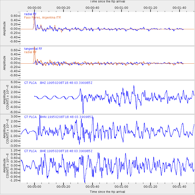
Signal To Noise
| Channel | StoN | STA | LTA |
| GT:PLCA: :BHN:19950208T18:48:03.390985Z | 4.2937093 | 1.0617222E-6 | 2.472739E-7 |
| GT:PLCA: :BHE:19950208T18:48:03.390985Z | 0.8727439 | 3.2182177E-7 | 3.6874707E-7 |
| GT:PLCA: :BHZ:19950208T18:48:03.390985Z | 5.3381286 | 2.1483854E-6 | 4.0246044E-7 |
| Arrivals |
| Ps | 4.3 SECOND |
| PpPs | 11 SECOND |
| PsPs/PpSs | 15 SECOND |


