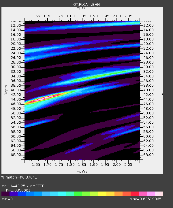
PLCA Paso Flores, Argentina - Earthquake Result Viewer
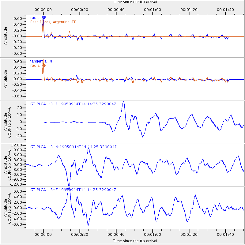
Earthquake location: Near Coast Of Guerrero, Mexico
Earthquake latitude/longitude: 16.8/-98.6
Earthquake time(UTC): 1995/09/14 (257) 14:04:31 GMT
Earthquake Depth: 21 km
Earthquake Magnitude: 6.4 MB, 7.2 MS, 7.2 UNKNOWN, 7.5 MW
Earthquake Catalog/Contributor: WHDF/NEIC
Network: GT Global Telemetered Seismograph Network (USAF/USGS)
Station: PLCA Paso Flores, Argentina
Lat/Lon: 40.73 S/70.55 W
Elevation: 1050 m
Distance: 62.9 deg
Az: 156.342 deg
Baz: 329.623 deg
Ray Param: 0.059881102
Estimated Moho Depth: 43.25 km
Estimated Crust Vp/Vs: 1.69
Assumed Crust Vp: 6.597 km/s
Estimated Crust Vs: 3.915 km/s
Estimated Crust Poisson's Ratio: 0.23
Radial Match: 96.37041 %
Radial Bump: 263
Transverse Match: 90.65569 %
Transverse Bump: 400
SOD ConfigId: 6273
Insert Time: 2010-02-27 02:13:39.194 +0000
GWidth: 2.5
Max Bumps: 400
Tol: 0.001

Signal To Noise

ChannelStoNSTALTA
GT:PLCA: :BHN:19950914T14:14:25.329004Z1.24716855.3768343E-74.311233E-7
GT:PLCA: :BHE:19950914T14:14:25.329004Z1.77342123.6915102E-72.0815756E-7
GT:PLCA: :BHZ:19950914T14:14:25.329004Z1.53114498.626413E-75.6339627E-7
Arrivals
Ps4.7 SECOND
PpPs17 SECOND
PsPs/PpSs21 SECOND