PLCA Paso Flores, Argentina - Earthquake Result Viewer
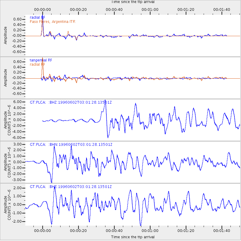
Earthquake location: Northern Mid-Atlantic Ridge
Earthquake latitude/longitude: 10.8/-42.3
Earthquake time(UTC): 1996/06/02 (154) 02:52:09 GMT
Earthquake Depth: 10 km
Earthquake Magnitude: 6.1 MB, 6.9 MS, 7.0 UNKNOWN, 6.8 MW
Earthquake Catalog/Contributor: WHDF/NEIC
Network: GT Global Telemetered Seismograph Network (USAF/USGS)
Station: PLCA Paso Flores, Argentina
Lat/Lon: 40.73 S/70.55 W
Elevation: 1050 m
Distance: 57.6 deg
Az: 205.268 deg
Baz: 33.497 deg
Ray Param: 0.0634142
Estimated Moho Depth: 38.75 km
Estimated Crust Vp/Vs: 1.68
Assumed Crust Vp: 6.597 km/s
Estimated Crust Vs: 3.939 km/s
Estimated Crust Poisson's Ratio: 0.22
Radial Match: 92.419556 %
Radial Bump: 294
Transverse Match: 80.61985 %
Transverse Bump: 400
SOD ConfigId: 6273
Insert Time: 2010-02-27 02:13:42.024 +0000
GWidth: 2.5
Max Bumps: 400
Tol: 0.001

Signal To Noise

ChannelStoNSTALTA
GT:PLCA: :BHN:19960602T03:01:28.13501Z7.08340021.1930965E-61.6843556E-7
GT:PLCA: :BHE:19960602T03:01:28.13501Z3.66101816.9751866E-71.9052587E-7
GT:PLCA: :BHZ:19960602T03:01:28.13501Z9.7224272.3143966E-62.3804719E-7
Arrivals
Ps4.2 SECOND
PpPs15 SECOND
PsPs/PpSs19 SECOND