You are here: Home > Network List > YN10 - San Jacinto Fault Zone Stations List
> Station GVAR1 GVAR1, Anza, CA, USA > Earthquake Result Viewer
GVAR1 GVAR1, Anza, CA, USA - Earthquake Result Viewer
| Earthquake location: |
Chile-Argentina Border Region |
| Earthquake latitude/longitude: |
-30.6/-70.5 |
| Earthquake time(UTC): |
2014/07/13 (194) 07:18:25 GMT |
| Earthquake Depth: |
91 km |
| Earthquake Magnitude: |
5.4 MW, 5.2 mb |
| Earthquake Catalog/Contributor: |
ISC/ISC |
|
| Network: |
YN San Jacinto Fault Zone |
| Station: |
GVAR1 GVAR1, Anza, CA, USA |
| Lat/Lon: |
33.67 N/116.71 W |
| Elevation: |
1328 m |
|
| Distance: |
77.4 deg |
| Az: |
321.882 deg |
| Baz: |
140.35 deg |
| Ray Param: |
0.050119042 |
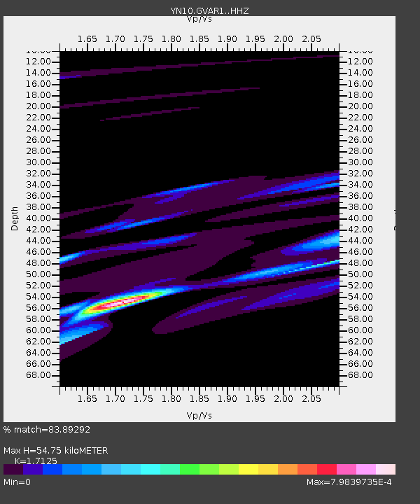
| Estimated Moho Depth: |
54.75 km |
| Estimated Crust Vp/Vs: |
1.71 |
| Assumed Crust Vp: |
6.264 km/s |
| Estimated Crust Vs: |
3.658 km/s |
| Estimated Crust Poisson's Ratio: |
0.24 |
|
| Radial Match: |
83.89292 % |
| Radial Bump: |
269 |
| Transverse Match: |
68.02442 % |
| Transverse Bump: |
190 |
| SOD ConfigId: |
3390531 |
| Insert Time: |
2019-04-12 20:03:47.681 +0000 |
| GWidth: |
2.5 |
| Max Bumps: |
400 |
| Tol: |
0.001 |
|

Signal To Noise
| Channel | StoN | STA | LTA |
| YN:GVAR1: :HHZ:20140713T07:29:39.81897Z | 1.3900121 | 0.0062202816 | 0.0044749836 |
| YN:GVAR1: :HHN:20140713T07:29:39.81897Z | 0.076926745 | 2.9300026E-7 | 3.8088215E-6 |
| YN:GVAR1: :HHE:20140713T07:29:39.81897Z | 0.38884652 | 1.0818488E-6 | 2.7822002E-6 |
| Arrivals |
| Ps | 6.4 SECOND |
| PpPs | 23 SECOND |
| PsPs/PpSs | 29 SECOND |


