You are here: Home > Network List > TA - USArray Transportable Network (new EarthScope stations) Stations List
> Station U52A Thorn Hill, TN, USA > Earthquake Result Viewer
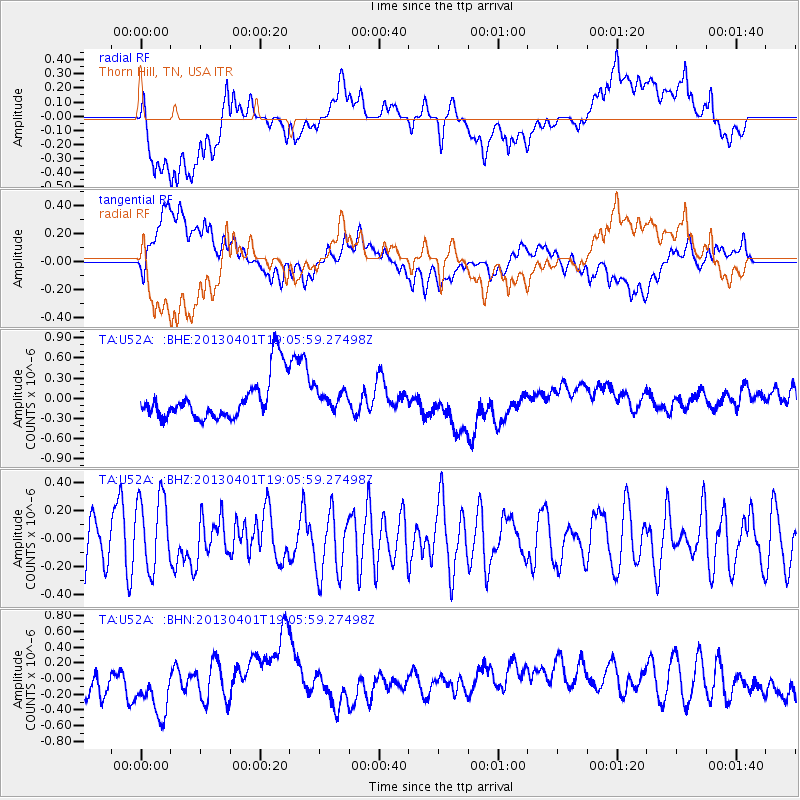
U52A Thorn Hill, TN, USA - Earthquake Result Viewer
*The percent match for this event was below the threshold and hence no stack was calculated.
| Earthquake location: |
Off East Coast Of Honshu, Japan |
| Earthquake latitude/longitude: |
39.5/143.2 |
| Earthquake time(UTC): |
2013/04/01 (091) 18:53:17 GMT |
| Earthquake Depth: |
14 km |
| Earthquake Magnitude: |
6.0 MW, 5.6 MB, 5.7 MS, 6.0 MW |
| Earthquake Catalog/Contributor: |
NEIC PDE/NEIC PDE-W |
|
| Network: |
TA USArray Transportable Network (new EarthScope stations) |
| Station: |
U52A Thorn Hill, TN, USA |
| Lat/Lon: |
36.39 N/83.37 W |
| Elevation: |
510 m |
|
| Distance: |
93.1 deg |
| Az: |
35.908 deg |
| Baz: |
325.793 deg |
| Ray Param: |
$rayparam |
*The percent match for this event was below the threshold and hence was not used in the summary stack. |
|
| Radial Match: |
37.256073 % |
| Radial Bump: |
400 |
| Transverse Match: |
38.466335 % |
| Transverse Bump: |
400 |
| SOD ConfigId: |
510825 |
| Insert Time: |
2013-09-04 22:21:22.722 +0000 |
| GWidth: |
2.5 |
| Max Bumps: |
400 |
| Tol: |
0.001 |
|
Signal To Noise
| Channel | StoN | STA | LTA |
| TA:U52A: :BHZ:20130401T19:05:59.27498Z | 1.8744854 | 2.6900713E-7 | 1.4350985E-7 |
| TA:U52A: :BHN:20130401T19:05:59.27498Z | 1.384102 | 4.2483776E-7 | 3.0694108E-7 |
| TA:U52A: :BHE:20130401T19:05:59.27498Z | 0.4252317 | 1.3418664E-7 | 3.155612E-7 |
| Arrivals |
| Ps | |
| PpPs | |
| PsPs/PpSs | |


