PLCA Paso Flores, Argentina - Earthquake Result Viewer
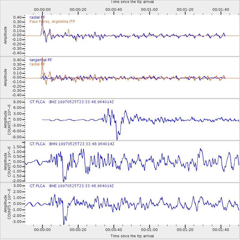
Earthquake location: South Of Kermadec Islands
Earthquake latitude/longitude: -32.1/179.8
Earthquake time(UTC): 1997/05/25 (145) 23:22:33 GMT
Earthquake Depth: 333 km
Earthquake Magnitude: 6.2 MB, 7.1 UNKNOWN, 7.0 MW
Earthquake Catalog/Contributor: WHDF/NEIC
Network: GT Global Telemetered Seismograph Network (USAF/USGS)
Station: PLCA Paso Flores, Argentina
Lat/Lon: 40.73 S/70.55 W
Elevation: 1050 m
Distance: 82.7 deg
Az: 133.824 deg
Baz: 233.673 deg
Ray Param: 0.045825105
Estimated Moho Depth: 10.75 km
Estimated Crust Vp/Vs: 1.72
Assumed Crust Vp: 6.597 km/s
Estimated Crust Vs: 3.847 km/s
Estimated Crust Poisson's Ratio: 0.24
Radial Match: 88.13508 %
Radial Bump: 384
Transverse Match: 54.73841 %
Transverse Bump: 400
SOD ConfigId: 6273
Insert Time: 2010-02-27 02:13:53.593 +0000
GWidth: 2.5
Max Bumps: 400
Tol: 0.001

Signal To Noise

ChannelStoNSTALTA
GT:PLCA: :BHN:19970525T23:33:48.964014Z0.71559112.0428716E-72.854803E-7
GT:PLCA: :BHE:19970525T23:33:48.964014Z0.915373441.8814002E-72.0553362E-7
GT:PLCA: :BHZ:19970525T23:33:48.964014Z2.88403326.1910515E-72.1466643E-7
Arrivals
Ps1.2 SECOND
PpPs4.3 SECOND
PsPs/PpSs5.5 SECOND