PLCA Paso Flores, Argentina - Earthquake Result Viewer
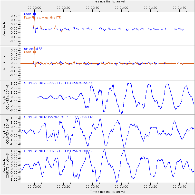
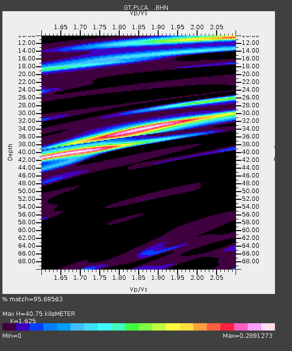
Earthquake location: Near Coast Of Guerrero, Mexico
Earthquake latitude/longitude: 16.3/-98.2
Earthquake time(UTC): 1997/07/19 (200) 14:22:08 GMT
Earthquake Depth: 33 km
Earthquake Magnitude: 5.7 MB, 6.3 MS, 6.8 UNKNOWN, 6.0 ME
Earthquake Catalog/Contributor: WHDF/NEIC
Network: GT Global Telemetered Seismograph Network (USAF/USGS)
Station: PLCA Paso Flores, Argentina
Lat/Lon: 40.73 S/70.55 W
Elevation: 1050 m
Distance: 62.3 deg
Az: 156.519 deg
Baz: 329.773 deg
Ray Param: 0.060249764
Estimated Moho Depth: 40.75 km
Estimated Crust Vp/Vs: 1.62
Assumed Crust Vp: 6.597 km/s
Estimated Crust Vs: 4.06 km/s
Estimated Crust Poisson's Ratio: 0.20
Radial Match: 95.69563 %
Radial Bump: 307
Transverse Match: 79.687164 %
Transverse Bump: 400
SOD ConfigId: 6273
Insert Time: 2010-02-27 02:13:57.067 +0000
GWidth: 2.5
Max Bumps: 400
Tol: 0.001

Signal To Noise

ChannelStoNSTALTA
GT:PLCA: :BHN:19970719T14:31:56.939014Z1.13013742.4191698E-72.1405977E-7
GT:PLCA: :BHE:19970719T14:31:56.939014Z1.1549992.387694E-72.0672692E-7
GT:PLCA: :BHZ:19970719T14:31:56.939014Z2.8229016.437245E-72.2803651E-7
Arrivals
Ps4.1 SECOND
PpPs15 SECOND
PsPs/PpSs19 SECOND